IMAGES TAKEN NEAR TO
Bramble Hill Farm, Five Oaks Road, HORSHAM, RH13 0TE
Introduction
This page details the photographs taken nearby to Bramble Hill Farm, Five Oaks Road, RH13 0TE by members of the Geograph project.
The Geograph project started in 2005 with the aim of publishing, organising and preserving representative images for every square kilometre of Great Britain, Ireland and the Isle of Man.

There are currently over 7.5m images from over14,400 individuals and you can help contribute to the project by visiting https://www.geograph.org.uk
Image Map
Images are licensed for reuse under creativecommons.org/licenses/by-sa/2.0
Notes
- Clicking on the map will re-center to the selected point.
- The higher the marker number, the further away the image location is from the centre of the postcode.
Image Listing (6 Images Found)
Images are licensed for reuse under creativecommons.org/licenses/by-sa/2.0
Image
Details
Distance
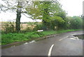
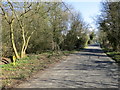
1
Track to Pinkhurst
Looking towards the junction with the Downs Link long distance path, close to the SE corner of the square.
Image: © Chris Shaw
Taken: 7 May 2006
0.09 miles
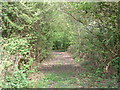
4
Public Footpath FP1467
1.763km off Bashurst Hill
Image: © The Saunterer
Taken: 6 Apr 2013
0.10 miles
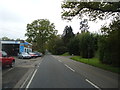
5
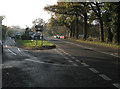
A264 Slinfold to Five Oaks road
Taken at the junction with the Coneyhurst road, facing south west. (Watch out for the GATSO camera!)
Image: © Chris Plunkett
Taken: 22 Nov 2005
0.11 miles