IMAGES TAKEN NEAR TO
Spring Lane, HORSHAM, RH13 0RT
Introduction
This page details the photographs taken nearby to Spring Lane, RH13 0RT by members of the Geograph project.
The Geograph project started in 2005 with the aim of publishing, organising and preserving representative images for every square kilometre of Great Britain, Ireland and the Isle of Man.

There are currently over 7.5m images from over14,400 individuals and you can help contribute to the project by visiting https://www.geograph.org.uk
Image Map (Loading...)


Getting Data...Please wait
Leaflet Map data © OpenStreetMap
Images are licensed for reuse under creativecommons.org/licenses/by-sa/2.0
Notes
- Clicking on the map will re-center to the selected point.
- The higher the marker number, the further away the image location is from the centre of the postcode.
Image Listing (39 Images Found)
Images are licensed for reuse under creativecommons.org/licenses/by-sa/2.0
Image
Details
Distance
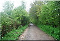
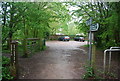
6
Downs Link at Slinfold, near Horsham
A view of the Downs Link path passing through Slinfold in West Sussex. The path follows a dismantled railway line. It also forms part of route 223 of the National Cycle Network. In this view, the path is approaching the site of Slinfold railway station.
Image: © Malc McDonald
Taken: 3 Jun 2022
0.07 miles
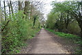
7
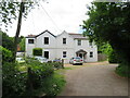
Houses at former railway station, Slinfold
The building in this image stands alongside the former railway station at Slinfold, in West Sussex. The station closed in 1965 and has since been demolished.
The driveway which heads off to the right forms part of the Downs Link path, which follows the dismantled railway line. The Downs Link path itself forms part of route 223 of the National Cycle Network.
More information about Slinfold station, including photographs taken when it was still open as a railway station, can be found on the Disused Stations website: http://www.disused-stations.org.uk/s/slinfold/
Image: © Malc McDonald
Taken: 3 Jun 2022
0.07 miles

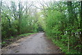
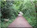
9
Downs Link by Slinfold
Excellently-surfaced section of the long distance path as it passes Slinfold. In the distance, the path has been diverted off the former trackbed which has now been taken over by a caravan site.
http://www.westsussex.gov.uk/leisureandtourism/prow/pdfs/DownsLinkRouteGuide.pdf
Image: © Colin Smith
Taken: 20 Jun 2009
0.09 miles
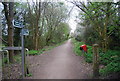
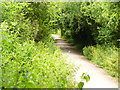
10
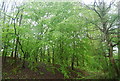
Trees on a railway embankment, Downs Link
Image: © N Chadwick
Taken: 2 May 2010
0.10 miles