IMAGES TAKEN NEAR TO
The Avenue, HORSHAM, RH13 0JE
Introduction
This page details the photographs taken nearby to The Avenue, RH13 0JE by members of the Geograph project.
The Geograph project started in 2005 with the aim of publishing, organising and preserving representative images for every square kilometre of Great Britain, Ireland and the Isle of Man.

There are currently over 7.5m images from over14,400 individuals and you can help contribute to the project by visiting https://www.geograph.org.uk
Image Map
Images are licensed for reuse under creativecommons.org/licenses/by-sa/2.0
Notes
- Clicking on the map will re-center to the selected point.
- The higher the marker number, the further away the image location is from the centre of the postcode.
Image Listing (64 Images Found)
Images are licensed for reuse under creativecommons.org/licenses/by-sa/2.0
Image
Details
Distance
1
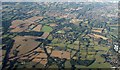
Christ's Hospital from the air
The central row of buildings from left to right is Christ's Hospital School. To the left is an extant and a disused railway line meeting, the latter branching away in the foreground and off to the left beyond the school. The squarish block of woodland across the line from the school is Shelley's Wood. The other principal curving feature is the A24 bypassing Horsham at upper right. The suburb to its left is Broadridge Heath. At lower right is the edge of Southwater.
Image: © Derek Harper
Taken: 3 Oct 2016
0.05 miles
2
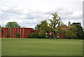
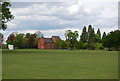
Christ's Hospital School
The school chapel is to the right of the photograph
Image: © N Chadwick
Taken: 3 May 2009
0.06 miles
3
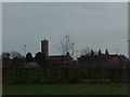
Christ's Hospital School
The famous 'Bluecoat School' moved here from London in 1902-3, It maintains strong links with the City, and the royal family. Its mission is to educate disadvantaged children, and maintain a healthy curriculum. It is primarily a boarding school.
Website: http://www.christs-hospital.org.uk
Image: © James 'Dan' Hall
Taken: Unknown
0.08 miles
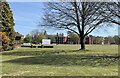
5
Part of Christ's Hospital School & School grounds
Image: © N Chadwick
Taken: 3 May 2009
0.09 miles
6
Christ?s Hospital
Christ’s Hospital is a school. For more details about the Grade II* (star) listed building see https://historicengland.org.uk/listing/the-list/list-entry/1027034
Image: © Chris Thomas-Atkin
Taken: 26 Apr 2021
0.11 miles
7
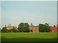
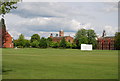
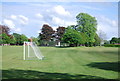
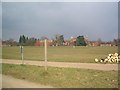
Christ's Hospital School and playing fields
Founded in 1552, Christ's Hospital School moved from the City of London to land on the Stammerham Estate bought from the bankrupted Aylesbury Dairy Company. The main buildings were designed by Sir Aston Webb and built between 1902 and 1903.
The school buildings straddle two grid-squares, the ones pictured here being in the east of this square. The school has extensive estates which cover almost all of this square as well as large areas in adjoining grid-squares.
Image: © Dan Gregory
Taken: 20 Sep 2008
0.11 miles
10
Fingerpost along public Bridleway BW1642
Through Christ's Hospital
Image: © The Saunterer
Taken: 23 Feb 2013
0.13 miles