IMAGES TAKEN NEAR TO
Colman Way, REDHILL, RH1 2AZ
Introduction
This page details the photographs taken nearby to Colman Way, RH1 2AZ by members of the Geograph project.
The Geograph project started in 2005 with the aim of publishing, organising and preserving representative images for every square kilometre of Great Britain, Ireland and the Isle of Man.

There are currently over 7.5m images from over14,400 individuals and you can help contribute to the project by visiting https://www.geograph.org.uk
Image Map
Images are licensed for reuse under creativecommons.org/licenses/by-sa/2.0
Notes
- Clicking on the map will re-center to the selected point.
- The higher the marker number, the further away the image location is from the centre of the postcode.
Image Listing (19 Images Found)
Images are licensed for reuse under creativecommons.org/licenses/by-sa/2.0
Image
Details
Distance
1
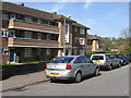
Moys House
One of a number of similar blocks in the Timperley Gardens estate of Redhill. Beyond can be seen another, Engles House.
Image: © Ian Capper
Taken: 26 Apr 2008
0.07 miles
2
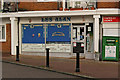
Les Alan, Butchers
A butchers' shop in Timperley Court (see Image)
Image: © Ian Capper
Taken: 14 Nov 2009
0.11 miles
3
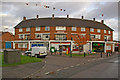
Timperley Court
A small shopping parade serving the local 1950s estate.
Image: © Ian Capper
Taken: 14 Nov 2009
0.11 miles
4
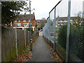
Path from Colebrooke Road to Timperley Gardens
An oddly high fence on the right, odd because the site is open to the road.
Image: © Robin Webster
Taken: 17 Nov 2010
0.13 miles
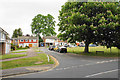
5
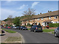
Colman Way
A road in the Green Lane area of Redhill
Image: © Ian Capper
Taken: 26 Apr 2008
0.16 miles
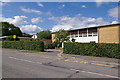
6
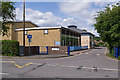
St Bede's School
A joint Church of England and Roman Catholic secondary school, founded in 1976 following the merger of the St Joseph’s RC Secondary School and Bishop Simpson Church of England Girls’ School.
Image: © Ian Capper
Taken: 17 Jul 2010
0.16 miles
8
Hurstleigh Drive
Seen from the junction with Park Road. An 1890 map of Redhill shows Hurstleigh as a large house on the site; three other roads nearby, Buckhurst Close and Eldersley Close and Elderlsey Gardens were similarly named after former houses.
Image: © Ian Capper
Taken: 26 Apr 2008
0.17 miles
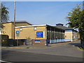
9
St Bede's School
A joint Church of England and Roman Catholic secondary school, founded in 1976 following the merger of the St Joseph’s RC Secondary School and Bishop Simpson Church of England Girls’ School.
Image: © Ian Capper
Taken: 17 Jul 2010
0.18 miles
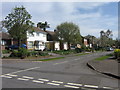
10
Regent Crescent
A residential crescent off Linkfield Lane which preserves a green.
Image: © Bill Boaden
Taken: 17 May 2019
0.22 miles