IMAGES TAKEN NEAR TO
Lynwick Street, HORSHAM, RH12 3UW
Introduction
This page details the photographs taken nearby to Lynwick Street, RH12 3UW by members of the Geograph project.
The Geograph project started in 2005 with the aim of publishing, organising and preserving representative images for every square kilometre of Great Britain, Ireland and the Isle of Man.

There are currently over 7.5m images from over14,400 individuals and you can help contribute to the project by visiting https://www.geograph.org.uk
Image Map
Images are licensed for reuse under creativecommons.org/licenses/by-sa/2.0
Notes
- Clicking on the map will re-center to the selected point.
- The higher the marker number, the further away the image location is from the centre of the postcode.
Image Listing (18 Images Found)
Images are licensed for reuse under creativecommons.org/licenses/by-sa/2.0
Image
Details
Distance
1
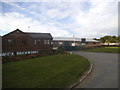
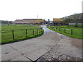
Rudgwick Brickworks
Sadly no longer in operation. Despite keeping the name it is now a business park including farming. There were piles of bricks in the front, now it is just the car park.
Image: © David Howard
Taken: 13 Sep 2015
0.02 miles
2
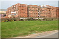
Rudgwick Brickworks
Lynwick Street, Rudgwick
Image: © Peter Jeffery
Taken: 1 Sep 2008
0.04 miles
5
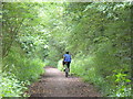
The Downslink
Cyclist on the long distance footpath between North and South Downs. This stretch west of Rudgwick follows the former Guildford-Horsham railway line which was open 1865-1965.
Image: © Colin Smith
Taken: 13 Jun 2008
0.11 miles
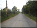
6
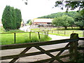
Woodsomes Farm, near Rudgwick
Woodsomes Farm in countryside close to the West Sussex/Surrey border.
Image: © Malc McDonald
Taken: 3 Jun 2022
0.13 miles
7
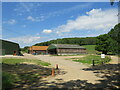
Woodsomes Farm
Large collection of farm buildings on the west side of The Downslink by Rudgwick.
Image: © Colin Smith
Taken: 13 Jun 2008
0.15 miles
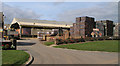
8
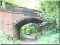
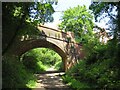
Lynwick Street Railway Bridge
The Guildford-Horsham railway is long gone (1865-1965) and the trackbed here is occupied by The Downslink path.
Image: © Colin Smith
Taken: 13 Jun 2008
0.17 miles
10
Bridge over the Downs Link path near Rudgwick
A view of the Downs Link path near Rudgwick in West Sussex. The path follows a dismantled railway line. It also forms part of route 223 of the National Cycle Network.
The bridge carries a road over the former railway line.
Image: © Malc McDonald
Taken: 3 Jun 2022
0.18 miles