IMAGES TAKEN NEAR TO
Bognor Road, HORSHAM, RH12 3SH
Introduction
This page details the photographs taken nearby to Bognor Road, RH12 3SH by members of the Geograph project.
The Geograph project started in 2005 with the aim of publishing, organising and preserving representative images for every square kilometre of Great Britain, Ireland and the Isle of Man.

There are currently over 7.5m images from over14,400 individuals and you can help contribute to the project by visiting https://www.geograph.org.uk
Image Map
Images are licensed for reuse under creativecommons.org/licenses/by-sa/2.0
Notes
- Clicking on the map will re-center to the selected point.
- The higher the marker number, the further away the image location is from the centre of the postcode.
Image Listing (11 Images Found)
Images are licensed for reuse under creativecommons.org/licenses/by-sa/2.0
Image
Details
Distance
1
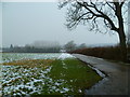
Farm road to Northlands from the A29
The road is also a public footpath.
Image: © Shazz
Taken: 23 Jan 2013
0.07 miles
2
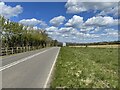
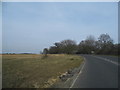
The A29
Walking alongside the A29 close to the border of Sussex with Surrey.
Image: © Chris Thomas-Atkin
Taken: 7 May 2021
0.13 miles
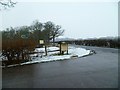
4
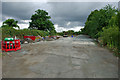
Road maintenance yard by A29
This yard is on the old road alignment, before the junction of Marches Road and Bognor Road (A29) was changed from a V- to a T-junction. Incidentally, on 1940s OS maps, both of these roads were labelled A29.
Image: © Robin Webster
Taken: 1 Aug 2010
0.15 miles
7
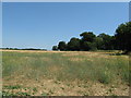
Barley field between the old and new A29
On the 1940's OS map the old A29 followed the path of the tree line, now it runs on the left side of the field. I'm not sure when the changes were made.
Image: © Dave Spicer
Taken: 1 Aug 2013
0.17 miles
9
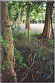
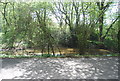
Bluebells in a Sussex Wealden Hedgerow.
A very mixed area of the Weald south-west of Kingsfold. Woodland, field, bluebells and hedgerow in a fenced line of trees are all visible.
Image: © Colin Smith
Taken: Unknown
0.21 miles
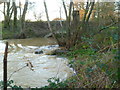
10
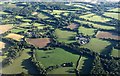
Farms near Winterfold
To the right is Dawes Farm, with Northlands, plus its business park, to the left. Between them flows the North River whose lining of trees hides it. Further left is the A29 Bognor Road.
Image: © Derek Harper
Taken: 3 Oct 2016
0.22 miles