IMAGES TAKEN NEAR TO
Billingshurst Road, HORSHAM, RH12 3LB
Introduction
This page details the photographs taken nearby to Billingshurst Road, RH12 3LB by members of the Geograph project.
The Geograph project started in 2005 with the aim of publishing, organising and preserving representative images for every square kilometre of Great Britain, Ireland and the Isle of Man.

There are currently over 7.5m images from over14,400 individuals and you can help contribute to the project by visiting https://www.geograph.org.uk
Image Map
Images are licensed for reuse under creativecommons.org/licenses/by-sa/2.0
Notes
- Clicking on the map will re-center to the selected point.
- The higher the marker number, the further away the image location is from the centre of the postcode.
Image Listing (48 Images Found)
Images are licensed for reuse under creativecommons.org/licenses/by-sa/2.0
Image
Details
Distance
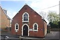
1
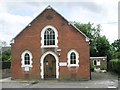
Brethren's Meeting Room
Built in 1908 as a daughter church of Image it was known as Broadbridge Heath Free Church until the late 1990s/early 2000s when its congregation had dissipated. It was the home of Busy Bees pre-school until the Unitarian church sold the property to its current owners.
Under the left-hand window is a commemorative stone made almost illegible by countless layers of paint. It reads, "This stone was laid by Mr Samuel Barrow of Burningfold Hall July 16th 1908"
Image: © Andy Potter
Taken: 12 May 2007
0.02 miles
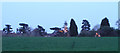
3
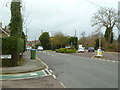
Junction of Billingshurst and Old Guildford Roads
Image: © Shazz
Taken: 26 Jan 2016
0.03 miles
4
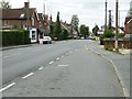
Old Guildford Road Broadbridge Heath
This was part of the main Horsham to Guildford road before the bypass was built around the village.
Image: © Dave Spicer
Taken: 14 Sep 2011
0.04 miles
5
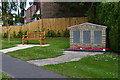
War memorial and bench at Broadbridge Heath
Image: © David Martin
Taken: 21 Jun 2015
0.04 miles
6
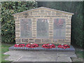
War Memorial, Broadbridge Heath
On the Billingshurst Road near Church of St John.
Image: © Andy Potter
Taken: 7 Sep 2006
0.04 miles
7
End of Public Bridleway BW1630
Where Church Road meets Old Guildford Road
Image: © The Saunterer
Taken: 14 Sep 2012
0.06 miles
8
Illuminations at the Shelley public house
Image: © Andy Potter
Taken: 21 Apr 2006
0.06 miles
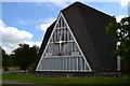
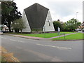
10
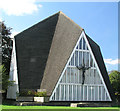
Church of St John
This unusual church, built in 1965, is in the shape of a "+" so it matches its symbol on Ordnance Survey maps!
Image: © Andy Potter
Taken: 7 Sep 2006
0.07 miles