IMAGES TAKEN NEAR TO
River Mead, Worthing Road, HORSHAM, RH12 1SP
Introduction
This page details the photographs taken nearby to River Mead, Worthing Road, RH12 1SP by members of the Geograph project.
The Geograph project started in 2005 with the aim of publishing, organising and preserving representative images for every square kilometre of Great Britain, Ireland and the Isle of Man.

There are currently over 7.5m images from over14,400 individuals and you can help contribute to the project by visiting https://www.geograph.org.uk
Image Map
Images are licensed for reuse under creativecommons.org/licenses/by-sa/2.0
Notes
- Clicking on the map will re-center to the selected point.
- The higher the marker number, the further away the image location is from the centre of the postcode.
Image Listing (328 Images Found)
Images are licensed for reuse under creativecommons.org/licenses/by-sa/2.0
Image
Details
Distance
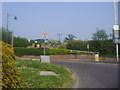
2
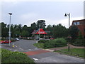
Worthing Road / Albion Way Roundabout
The roundabout at the junction of Albion Way & Worthing Road
Image: © Dave Grainger
Taken: 6 Aug 2008
0.04 miles
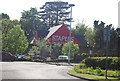
3
Tanbridge House
Built in 1887 with the profits of the railway boom by Sir Thomas Oliver. It was the home of Horsham High School for girls from 1924 to 1979. It has since been converted into apartments with the grounds being filled with houses.
Subsequent to posting this image I was researching another location on the West Sussex Past website http://www.westsussexpast.org/pictures/ and found a postcard of this building from 1933 http://www.westsussexpast.org/pictures/GetImage.ashx?db=Catalog&type=default&fname=PP_WSL_PC004774+copy.jpg which appears to have been taken from exactly the same angle but slightly further away producing an almost identical image. Perhaps I do have a photographer's eye, albeit an old fashioned one!
Image: © Andy Potter
Taken: 8 May 2007
0.07 miles
4
Junction of Worthing Road and Albion Way
Image: © David Howard
Taken: 24 Apr 2011
0.07 miles
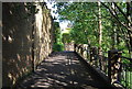
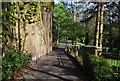
6
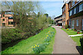
Riverside walk, Horsham
The River Arun is rather insignificant downstream of the Provender Mill. Upstream it is much more impressive.
Image: © Robin Webster
Taken: 13 Apr 2010
0.08 miles
7
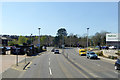
Horsham partial ring road
This links routes radiating from the town to nominally east, north, west and south, but the south - east part is missing.
Image: © Robin Webster
Taken: 18 Apr 2018
0.10 miles
8
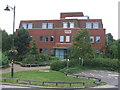
Saxon Weald House
On Worthing Road, next to the Image
Image: © Dave Grainger
Taken: 6 Aug 2008
0.11 miles
9
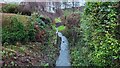
River Arun
Overflow stream that maybe the original River Arun route. A higher level canal was cut for the mill.
River info : https://en.wikipedia.org/wiki/River_Arun
Image: © James Emmans
Taken: 27 Dec 2021
0.11 miles