IMAGES TAKEN NEAR TO
Churchill Close, REDHILL, RH1 1SB
Introduction
This page details the photographs taken nearby to Churchill Close, RH1 1SB by members of the Geograph project.
The Geograph project started in 2005 with the aim of publishing, organising and preserving representative images for every square kilometre of Great Britain, Ireland and the Isle of Man.

There are currently over 7.5m images from over14,400 individuals and you can help contribute to the project by visiting https://www.geograph.org.uk
Image Map
Images are licensed for reuse under creativecommons.org/licenses/by-sa/2.0
Notes
- Clicking on the map will re-center to the selected point.
- The higher the marker number, the further away the image location is from the centre of the postcode.
Image Listing (127 Images Found)
Images are licensed for reuse under creativecommons.org/licenses/by-sa/2.0
Image
Details
Distance
1
Spruce Close
Early 21st century development on the site of the former driving test centre.
Image: © Ian Capper
Taken: 12 May 2012
0.06 miles
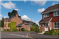
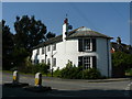
2
The Stables, Linkfield Lane
At the junction of Linkfield Lane and Daneshill. The curved building on the left is early 19th century, with the white building behind being 18th century - both are locally listed. An 1895 map of Redhill shows them to be in the grounds of a large building called Woodside, the home of a certain Tilson Lee, suggesting that these were the outbuildings for the house. Tilson Lee was clearly an art collector - a 1639 picture by Dirck Santvoort, "Portrait of Geertruyt Spiegel with a Finch", is listed by the National Gallery as having been donated by him in 1916, while another website records him as having been the seller of another 17th century Dutch painting "at his Sale on the premises Woodside, Surrey, 11-12 May 1920".
Image: © Ian Capper
Taken: 26 Apr 2008
0.06 miles
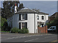
3
Houses by Linkfield Lane, Redhill
See also http://www.geograph.org.uk/gridref/TQ2750?centi=TQ274509 ; this view of The Stables is from a little further east along Linkfield Lane.
Image: © Derek Harper
Taken: 15 Oct 2011
0.07 miles
4
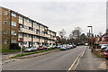
North Street
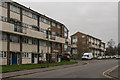
Looking along North Street. On the left is Rother House, part of the mid 1960s Rivers Estate off North Street, with all blocks named after rivers.
Image: © Ian Capper
Taken: 27 Feb 2016
0.07 miles
5
Wandle House and Rother House
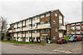
Looking across North Street to Wandle House (on the left) and Rother House, part of the mid 1960s Rivers Estate off North Street, with all blocks named after rivers.
Image: © Ian Capper
Taken: 27 Feb 2016
0.07 miles
6
Wandle House
Looking across North Street to Wandle House, part of the mid 1960s Rivers Estate off North Street, with all blocks named after rivers. In the background is part of Windrush House.
Image: © Ian Capper
Taken: 27 Feb 2016
0.07 miles
7
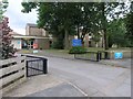
School
St Matthews Church of England School
Image: © Hywel Williams
Taken: 4 Jul 2005
0.07 miles
8
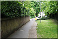
Park Road
The southern end of Park Road is a private road, and as can be seen here, it is reduced to just a path as it continues through to Linkfield Lane.
Image: © Bill Boaden
Taken: 17 May 2019
0.07 miles
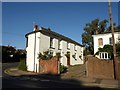
9
House on Daneshill, Redhill
Situated at the bottom of Daneshill, at the junction with Linkfield Lane.
Image: © Peter Trimming
Taken: 24 May 2009
0.08 miles
10
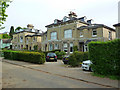
Park Road
Victorian villas built in the mid 19th century as part of the Warwick Town, an area developed on land owned by the Countess of Brooke and Warwick, widow of the fourth Lord Monson, who lived at Gatton Hall, following the arrival of the railway.
Image: © Ian Capper
Taken: 4 May 2009
0.08 miles