IMAGES TAKEN NEAR TO
London Road, REDHILL, RH1 1LY
Introduction
This page details the photographs taken nearby to London Road, RH1 1LY by members of the Geograph project.
The Geograph project started in 2005 with the aim of publishing, organising and preserving representative images for every square kilometre of Great Britain, Ireland and the Isle of Man.

There are currently over 7.5m images from over14,400 individuals and you can help contribute to the project by visiting https://www.geograph.org.uk
Image Map
Images are licensed for reuse under creativecommons.org/licenses/by-sa/2.0
Notes
- Clicking on the map will re-center to the selected point.
- The higher the marker number, the further away the image location is from the centre of the postcode.
Image Listing (602 Images Found)
Images are licensed for reuse under creativecommons.org/licenses/by-sa/2.0
Image
Details
Distance
1
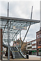
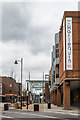
Steps and canopy, High Street
New canopy and entrance to the Harlequin theatre and Redhill Library built in 2016 as part of the Warwick Quadrant redevelopment, replacing the previous one dating from 1986 (see Image).
Image: © Ian Capper
Taken: 1 Apr 2018
0.01 miles
2
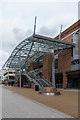
Steps and canopy, High Street
New canopy and entrance to the Harlequin theatre and Redhill Library built in 2016 as part of the Warwick Quadrant redevelopment, replacing the previous one dating from 1986 (see Image).
Image: © Ian Capper
Taken: 1 Apr 2018
0.01 miles
3
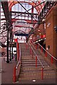
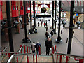
Steps to the Harlequin Theatre
Steps leading up to Redhill Library and the Harlequin Theatre, part of the 1982 Warwick Quadrant development, with the canopy dating from 1986.
Image: © Ian Capper
Taken: 29 Aug 2011
0.01 miles
4
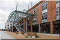
Steps and canopy, High Street
New canopy and entrance to the Harlequin theatre and Redhill Library built in 2016 as part of the Warwick Quadrant redevelopment, replacing the previous one dating from 1986 (see Image).
Image: © Ian Capper
Taken: 1 Apr 2018
0.01 miles
5
High Street
Looking along High Street from its junction with Station Road, with part of the 1982 Warwick Quadrant on the right, this corner previously being the site of the Market Hall, dating from 1859 onwards.
Compare Image - the original canopy, added in 1986, was replaced in 2016 as part of the Warwick Quadrant redevelopment.
Image: © Ian Capper
Taken: 1 Apr 2018
0.01 miles
6
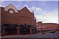
Warwick Quadrant, Redhill
Warwick Quadrant, a theatre, cinema and library complex, was built on the site of the Market Hall, demolished in 1982. The name derives from Countess Brooke of Warwick, a member of a local landowning family; Redhill was known as Warwick Town for a brief period in the 19th century.
Image: © Stephen McKay
Taken: 7 Apr 2008
0.02 miles
7
The Sun
A Wetherspoon pub opened on 14 August 1996.
Its name commemorates the work of the 19th century amateur astronomer Richard Carrington, who lived at "The Dome", a large house nearby which included an observatory. The house has since been demolished and replaced by a block of flats (see Image). His most famous work involved studying the Sun, and it is after him that the sunspot cycle is named, hence the link with the pub name.
Image: © Ian Capper
Taken: 29 Aug 2011
0.02 miles
8
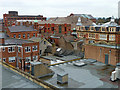
Rooftops, Redhill
Looking north-east from the Belfry roof car park.
Image: © Robin Webster
Taken: 17 Nov 2010
0.02 miles
9
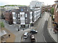
Queensway (A25), Redhill
The thoroughfare at left is the pedestrianised London Road.
Image: © Rib
Taken: 25 Apr 2018
0.03 miles
10
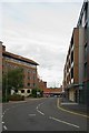
Queensway
Part of the Redhill ring road. On the right is Nobel House (see Image) and on the left is Consort House (see Image).
Image: © Ian Capper
Taken: 29 Aug 2011
0.03 miles