IMAGES TAKEN NEAR TO
Huntingdon Road, REDHILL, RH1 1HP
Introduction
This page details the photographs taken nearby to Huntingdon Road, RH1 1HP by members of the Geograph project.
The Geograph project started in 2005 with the aim of publishing, organising and preserving representative images for every square kilometre of Great Britain, Ireland and the Isle of Man.

There are currently over 7.5m images from over14,400 individuals and you can help contribute to the project by visiting https://www.geograph.org.uk
Image Map
Images are licensed for reuse under creativecommons.org/licenses/by-sa/2.0
Notes
- Clicking on the map will re-center to the selected point.
- The higher the marker number, the further away the image location is from the centre of the postcode.
Image Listing (541 Images Found)
Images are licensed for reuse under creativecommons.org/licenses/by-sa/2.0
Image
Details
Distance
1
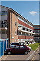
Grove House
Part of the Cromwell Road Estate.
Image: © Ian Capper
Taken: 1 Apr 2012
0.01 miles
2
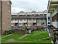
Flats, Redhill
The far block, mostly boarded up, are above shops on Cromwell Road on the far side. The block has now been demolished.
Image: © Robin Webster
Taken: 17 Nov 2010
0.02 miles
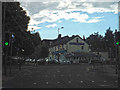
3
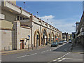
Cromwell Road
From the junction with Huntingdon Road, with the Belfry Shopping Centre on the left.
Image: © Ian Capper
Taken: 26 Apr 2008
0.02 miles
4
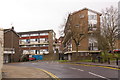
Cromwell Road estate, Redhill
A former council estate immediately south of Redhill town centre.
Image: © Ian Capper
Taken: 24 Mar 2008
0.02 miles
5
Cromwell Road
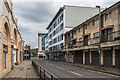
Looking along Cromwell Road, with part of the Belfry shopping centre on the left. On the right is 16-46 Cromwell Road, a 1960/70s development of retails and residential units owned by Reigate and Banstead Borough Council, now largely vacant. Following the completion of Queensgate, a conversion of a privately owned office block into 64 residential units completed in 2017, the council is proposing a similar development for this site. A previous plan for a supermarket on the site was dropped in 2014.
Image: © Ian Capper
Taken: 1 Apr 2018
0.03 miles
6
Queensgate
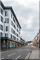
Redevelopment completed in 2017 of the former Knowles House on the corner of High Street and Cromwell Road. Knowles House was a three storey office block, which has been stripped back and then extended upwards to provide 64 residential units. This photo is looking along Cromwell Road, with part of the Belfry shopping centre on the right.
Image: © Ian Capper
Taken: 1 Apr 2018
0.03 miles
7
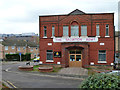
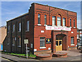
Salvation Army, Redhill
Dated 1890 above, it seems to have four foundation stones as well.
Image: © Robin Webster
Taken: 17 Nov 2010
0.03 miles
8
Salvation Army Citadel
At the junction of Sincots Road (on the left) and Lower Bridge Street (on the right). Dating from 1890, when this area consisted of terraced housing, now replaced by the Cromwell Road housing estate, buildings of which can be seen in the background on both sides of the citadel.
Image: © Ian Capper
Taken: 26 Apr 2008
0.03 miles
9
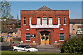
Salvation Army Citadel
Dating from 1890, when this area consisted of terraced housing, now replaced by the Cromwell Road housing estate, buildings of which can be seen in the background on both sides of the citadel.
In the background is the spire of St Matthew's Church.
Image: © Ian Capper
Taken: 1 Apr 2012
0.03 miles
10
Redhill : Cromwell Road
Looking along Cromwell Road with Everest Spice at the end of the road.
Image: © Lewis Clarke
Taken: 6 Jul 2014
0.03 miles