IMAGES TAKEN NEAR TO
Station Road, REDHILL, RH1 1HF
Introduction
This page details the photographs taken nearby to Station Road, RH1 1HF by members of the Geograph project.
The Geograph project started in 2005 with the aim of publishing, organising and preserving representative images for every square kilometre of Great Britain, Ireland and the Isle of Man.

There are currently over 7.5m images from over14,400 individuals and you can help contribute to the project by visiting https://www.geograph.org.uk
Image Map
Images are licensed for reuse under creativecommons.org/licenses/by-sa/2.0
Notes
- Clicking on the map will re-center to the selected point.
- The higher the marker number, the further away the image location is from the centre of the postcode.
Image Listing (185 Images Found)
Images are licensed for reuse under creativecommons.org/licenses/by-sa/2.0
Image
Details
Distance
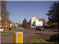
2
Lewis Court
Newly completed retirement housing on Linkfield Corner.
Image: © Ian Capper
Taken: 21 Mar 2009
0.03 miles
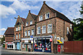
3
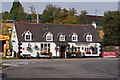
The Red Lion
This locally listed building dates from the 16th century, and according to its website is the second oldest in Redhill. The oldest, or at least the longest continuously licensed, is the White Lion - see Image
One claim for fame is that it was once the local of Ronnie Biggs, of Great Train Robbery infamy.
Behind is Donyngs Recreation Centre (see Image).
Image: © Ian Capper
Taken: 9 Oct 2011
0.06 miles
4
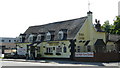
The Red Lion, Redhill
Situated by the roundabout at the end of Hatchlands Road.
Image: © Peter Trimming
Taken: 24 May 2009
0.06 miles
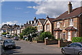
5
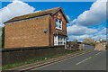
37 Linkfield Street
Single house on Linkfield Street next to the bridge over the Redhill to Reigate railway. A date plaque on the front is inscribed 1910.
Image: © Ian Capper
Taken: 1 Mar 2020
0.06 miles
6
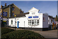
Somers House
Built in 1853, for many years this was a pub, known as the Somers Arms, the second such pub in Redhill, the first (see Image) having closed in 1846. It is now the offices of an estate agent.
Image: © Ian Capper
Taken: 15 Mar 2009
0.07 miles
7
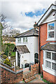
10 Linkfield Street
Victorian cottage in Linkfield Street.
Image: © Ian Capper
Taken: 1 Mar 2020
0.07 miles
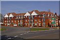
8
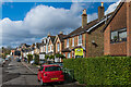
Charman Road
Late Victorian/early 20th Century housing in Charman Road.
Image: © Ian Capper
Taken: 1 Mar 2020
0.08 miles
9
Raffles Bridge shops
Row of shops on Raffles Bridge. In the background on the left of the photo is The Dome (see Image).
Image: © Ian Capper
Taken: 16 Jun 2013
0.08 miles
10
Charman Road
Part of the late Victorian development of the area between Linkfield Street and Hatchlands Road. The name is presumably derived from the name of Charles Charman Elgar, who owned much of the area in the mid 19th century.
Image: © Ian Capper
Taken: 12 Sep 2010
0.08 miles