IMAGES TAKEN NEAR TO
Warwick Road, REDHILL, RH1 1FQ
Introduction
This page details the photographs taken nearby to Warwick Road, RH1 1FQ by members of the Geograph project.
The Geograph project started in 2005 with the aim of publishing, organising and preserving representative images for every square kilometre of Great Britain, Ireland and the Isle of Man.

There are currently over 7.5m images from over14,400 individuals and you can help contribute to the project by visiting https://www.geograph.org.uk
Image Map
Images are licensed for reuse under creativecommons.org/licenses/by-sa/2.0
Notes
- Clicking on the map will re-center to the selected point.
- The higher the marker number, the further away the image location is from the centre of the postcode.
Image Listing (382 Images Found)
Images are licensed for reuse under creativecommons.org/licenses/by-sa/2.0
Image
Details
Distance
1
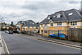
Centenary Court
Block of 8 apartments in Warwick Road, built in 2001 and numbered 30 Warwick Road. Beyond is Annandale Court (5 apartments) and the connected Gloucester Court (10 apartments) both built at the same time and numbered 32 an 34 Warwick Road respectively.
Image: © Ian Capper
Taken: 1 Apr 2018
0.01 miles
2
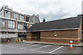
Masjid al Yaqeen
Mosque in Warwick Road. In the background is Redhill Telephone Exchange.
Image: © Ian Capper
Taken: 1 Apr 2018
0.01 miles
3
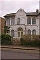
House in Warwick Road, Redhill
This house is one of the few remnants of the Victorian settlement, Warwick Town, that grew up near Reigate Junction, out of which emerged the present day Redhill. Note the statue of Queen Victoria in the gable above the front door.
Image: © Ian Capper
Taken: 23 Mar 2008
0.02 miles
4
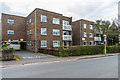
Jefferson Court
Block of 20 apartments in Warwick Road, numbered 47-49 Warwick Road.
Image: © Ian Capper
Taken: 1 Apr 2018
0.02 miles
5
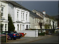
Gloucester Road, Redhill
Looking along Gloucester Road from the junction with Clarendon Road.
Image: © Stephen McKay
Taken: 7 Apr 2008
0.03 miles
6
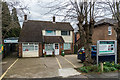
Redhill Children's Centre
Family support centre in Warwick Road, run by the charity Welcare.
Image: © Ian Capper
Taken: 1 Apr 2018
0.04 miles
7
Gloucester Road, Redhill
Substantial semi-detached villas to the north of the town centre.
Image: © Stephen McKay
Taken: 7 Apr 2008
0.04 miles
8
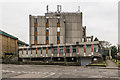
Redhill Telephone Exchange
Built in the early 1970s in Clarendon Road.
Image: © Ian Capper
Taken: 27 Feb 2016
0.04 miles
9
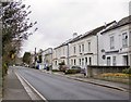
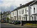
Gloucester Road, Redhill
Substantial mid-19th century semis line this residential street close to the town centre. On architectural grounds I'd date these houses somewhere between 1830 and 1850. The railways reached Redhill in 1841 (the Brighton line, LB&SCR) and 1842 (the South Eastern) - so it seems likely that Gloucester Road was part of an early phase in the town's expansion.
It's worth mentioning that the first Redhill station was (at first) known as 'Reigate' - railways passing through humble districts often chose to give their station the name of a 'posher' neighbouring community. A well-known example is Clapham Junction, which is in Battersea.
Image: © Stefan Czapski
Taken: 18 Feb 2012
0.05 miles
10
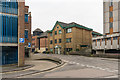
Clarendon Road
Offices and car park in the centre of Redhill.
Image: © Ian Capper
Taken: 27 Feb 2016
0.05 miles