IMAGES TAKEN NEAR TO
North Street, REDHILL, RH1 1EW
Introduction
This page details the photographs taken nearby to North Street, RH1 1EW by members of the Geograph project.
The Geograph project started in 2005 with the aim of publishing, organising and preserving representative images for every square kilometre of Great Britain, Ireland and the Isle of Man.

There are currently over 7.5m images from over14,400 individuals and you can help contribute to the project by visiting https://www.geograph.org.uk
Image Map
Images are licensed for reuse under creativecommons.org/licenses/by-sa/2.0
Notes
- Clicking on the map will re-center to the selected point.
- The higher the marker number, the further away the image location is from the centre of the postcode.
Image Listing (178 Images Found)
Images are licensed for reuse under creativecommons.org/licenses/by-sa/2.0
Image
Details
Distance
1
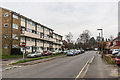
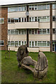
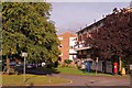
North Street
Looking along North Street. On the left is Rother House, part of the mid 1960s Rivers Estate off North Street, with all blocks named after rivers.
Image: © Ian Capper
Taken: 27 Feb 2016
0.00 miles
2
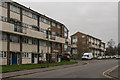
Wandle House and Rother House
Looking across North Street to Wandle House (on the left) and Rother House, part of the mid 1960s Rivers Estate off North Street, with all blocks named after rivers.
Image: © Ian Capper
Taken: 27 Feb 2016
0.03 miles
3
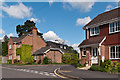
Spruce Close
Early 21st century development on the site of the former driving test centre.
Image: © Ian Capper
Taken: 12 May 2012
0.03 miles
4
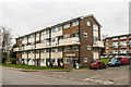
Wandle House
Looking across North Street to Wandle House, part of the mid 1960s Rivers Estate off North Street, with all blocks named after rivers. In the background is part of Windrush House.
Image: © Ian Capper
Taken: 27 Feb 2016
0.03 miles
5
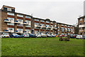
Mermaid bench
Mermaid bench in Rutland Close in the mid 1960s Rivers Estate off North Street, with all blocks named after rivers. Behind is part of Wandle House.
Image: © Ian Capper
Taken: 27 Feb 2016
0.04 miles
6
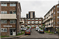
Windrush House and Orwell House
Two blocks in Rutland Close in the mid 1960s Rivers Estate off North Street, with all blocks named after rivers. In the left background is the top of The Dome (see Image).
Image: © Ian Capper
Taken: 27 Feb 2016
0.04 miles
7
Rutland Close
Part of the mid 1960s Rivers Estate off North Street, with all blocks named after rivers. In the background is The Dome (see Image).
Image: © Ian Capper
Taken: 27 Feb 2016
0.04 miles
8
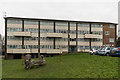
Avon House
Block in Rutland Close in the mid 1960s Rivers Estate off North Street, with all blocks named after rivers. In the background is The Dome (see Image).
Image: © Ian Capper
Taken: 27 Feb 2016
0.05 miles
9
Flint Close
Housing at the junction of North Street and Linkfield Lane.
Image: © Ian Capper
Taken: 29 Aug 2011
0.05 miles
10
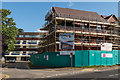
West Mount
New housing under construction on Linkfield Lane on the site of Colne House, part of the mid 1960s Rivers Estate. For the completed building see Image In the left background is Kennet House, one of the original blocks.
Image: © Ian Capper
Taken: 3 Aug 2014
0.05 miles