IMAGES TAKEN NEAR TO
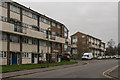
Rutland Close, REDHILL, RH1 1EH
Introduction
This page details the photographs taken nearby to Rutland Close, RH1 1EH by members of the Geograph project.
The Geograph project started in 2005 with the aim of publishing, organising and preserving representative images for every square kilometre of Great Britain, Ireland and the Isle of Man.

There are currently over 7.5m images from over14,400 individuals and you can help contribute to the project by visiting https://www.geograph.org.uk
Image Map
Images are licensed for reuse under creativecommons.org/licenses/by-sa/2.0
Notes
- Clicking on the map will re-center to the selected point.
- The higher the marker number, the further away the image location is from the centre of the postcode.
Image Listing (271 Images Found)
Images are licensed for reuse under creativecommons.org/licenses/by-sa/2.0
Image
Details
Distance
1
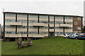
Avon House
Block in Rutland Close in the mid 1960s Rivers Estate off North Street, with all blocks named after rivers. In the background is The Dome (see Image).
Image: © Ian Capper
Taken: 27 Feb 2016
0.01 miles
2
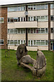
Mermaid bench
Mermaid bench in Rutland Close in the mid 1960s Rivers Estate off North Street, with all blocks named after rivers. Behind is part of Wandle House.
Image: © Ian Capper
Taken: 27 Feb 2016
0.02 miles
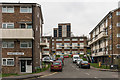
3
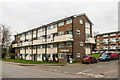
Wandle House
Looking across North Street to Wandle House, part of the mid 1960s Rivers Estate off North Street, with all blocks named after rivers. In the background is part of Windrush House.
Image: © Ian Capper
Taken: 27 Feb 2016
0.03 miles
4
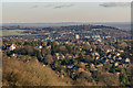
Redhill from Reigate Hill
Looking towards central Redhill from Reigate Hill. Prominent features are Hethersett on the left (see Image), the Dome in the centre (see Image, Redhill town centre office buildings to its right, in particular RedCentral and Kingsgate (see Image) and Bridge Gate (see Image) and Wray Common Windmill in front of them (see Image). Behind is Redstone Hill, with the Weald near East Grinstead in the distance and the High Weald just visible beyond.
Image: © Ian Capper
Taken: 15 Jan 2016
0.03 miles
5
Wandle House and Rother House
Looking across North Street to Wandle House (on the left) and Rother House, part of the mid 1960s Rivers Estate off North Street, with all blocks named after rivers.
Image: © Ian Capper
Taken: 27 Feb 2016
0.03 miles
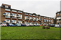
6
Rutland Close
Part of the mid 1960s Rivers Estate off North Street, with all blocks named after rivers. In the background is The Dome (see Image).
Image: © Ian Capper
Taken: 27 Feb 2016
0.03 miles
7
Windrush House and Orwell House
Two blocks in Rutland Close in the mid 1960s Rivers Estate off North Street, with all blocks named after rivers. In the left background is the top of The Dome (see Image).
Image: © Ian Capper
Taken: 27 Feb 2016
0.04 miles
8
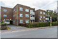
Jefferson Court
Block of 20 apartments in Warwick Road, numbered 47-49 Warwick Road.
Image: © Ian Capper
Taken: 1 Apr 2018
0.05 miles
9
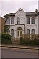
House in Warwick Road, Redhill
This house is one of the few remnants of the Victorian settlement, Warwick Town, that grew up near Reigate Junction, out of which emerged the present day Redhill. Note the statue of Queen Victoria in the gable above the front door.
Image: © Ian Capper
Taken: 23 Mar 2008
0.06 miles
10
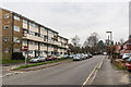
North Street
Looking along North Street. On the left is Rother House, part of the mid 1960s Rivers Estate off North Street, with all blocks named after rivers.
Image: © Ian Capper
Taken: 27 Feb 2016
0.06 miles