IMAGES TAKEN NEAR TO
Hatchlands Road, REDHILL, RH1 1BG
Introduction
This page details the photographs taken nearby to Hatchlands Road, RH1 1BG by members of the Geograph project.
The Geograph project started in 2005 with the aim of publishing, organising and preserving representative images for every square kilometre of Great Britain, Ireland and the Isle of Man.

There are currently over 7.5m images from over14,400 individuals and you can help contribute to the project by visiting https://www.geograph.org.uk
Image Map
Images are licensed for reuse under creativecommons.org/licenses/by-sa/2.0
Notes
- Clicking on the map will re-center to the selected point.
- The higher the marker number, the further away the image location is from the centre of the postcode.
Image Listing (103 Images Found)
Images are licensed for reuse under creativecommons.org/licenses/by-sa/2.0
Image
Details
Distance
1
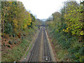
Redhill - Guildford line looking towards Redhill
The third rail only extends west as far as Reigate.
Image: © Robin Webster
Taken: 17 Nov 2010
0.12 miles
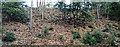
3

Former sand quarry
Former sand quarry, known as Doods Road Pit. The quarry was served by a siding off the Redhill - Reigate railway. This view, screened by a fence and small trees, is from Madeira Walk, which overlooks the former quarry site on both sides.
Image: © Ian Capper
Taken: 18 Jan 2021
0.13 miles
4
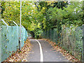
Path beside railway, Redhill
The railway is to the left, in a cutting.
Image: © Robin Webster
Taken: 17 Nov 2010
0.14 miles
5
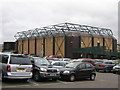
Donyngs Recreation Centre
An indoor sports centre/swimming pool complex serving Reigate and Redhill, built in the 1980s.
Image: © Ian Capper
Taken: 23 Feb 2008
0.14 miles
6
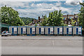
Temporary accommodation
A row of "Bunkabins" (TM) in Donyngs car park, set up by Reigate and Banstead Borough Council to provide temporary accommodation to otherwise homeless people during the COVID-19 pandemic, utilising the space made available through the closure of the leisure centre.
Image: © Ian Capper
Taken: 13 Jun 2020
0.14 miles
7

Greensand outcrop by the North Downs Line
Image: © N Chadwick
Taken: 30 Jan 2016
0.14 miles
8
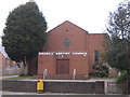
Redhill Baptist Church
In Hatchlands Road, Redhill. The church here was built in 1959, having previously been based in London Road, Redhill, opposite what is now the Harlequin Centre.
Image: © Ian Capper
Taken: 23 Feb 2008
0.15 miles
9
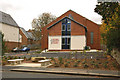
Redhill Baptist Church
Originally built here in 1959, it was completely refurbished in 2009, the new building opening in October of that year. For comparison with previous appearance see Image
Image: © Ian Capper
Taken: 17 Oct 2009
0.15 miles
10
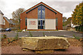
Redhill Baptist Church
Originally built here in 1959, it was completely refurbished in 2009, the new building opening in October of that year. Adjacent to the pavement of Hatchlands Road the pavement, next to a seating area, is this large rock inscribed with the words "hope" and "peace".
Image: © Ian Capper
Taken: 17 Oct 2009
0.15 miles