IMAGES TAKEN NEAR TO
The Squires, CRAWLEY, RH11 9BU
Introduction
This page details the photographs taken nearby to The Squires, RH11 9BU by members of the Geograph project.
The Geograph project started in 2005 with the aim of publishing, organising and preserving representative images for every square kilometre of Great Britain, Ireland and the Isle of Man.

There are currently over 7.5m images from over14,400 individuals and you can help contribute to the project by visiting https://www.geograph.org.uk
Image Map
Images are licensed for reuse under creativecommons.org/licenses/by-sa/2.0
Notes
- Clicking on the map will re-center to the selected point.
- The higher the marker number, the further away the image location is from the centre of the postcode.
Image Listing (80 Images Found)
Images are licensed for reuse under creativecommons.org/licenses/by-sa/2.0
Image
Details
Distance
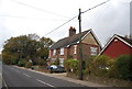
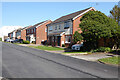
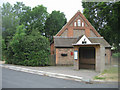
1
Housing on The Squires, Pease Pottage
Image: © Robin Webster
Taken: 30 Mar 2021
0.04 miles
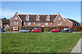
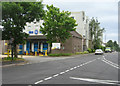
2
The Grapes (closed), Pease Pottage
The agent's board describes it as 'Former pub / Development opportunity'. It was later demolished and replaced with houses.
Image: © Robin Webster
Taken: 9 Jan 2010
0.06 miles
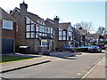
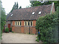
4
Houses on Old Brighton Road (South), Pease Pottage
For what was here before these were built, see Image
Image: © Robin Webster
Taken: 30 Mar 2021
0.07 miles
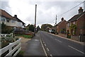
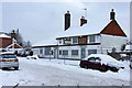
7
Old Brighton Road (South)
Once a busy road, now a quiet access route following the building of the A23.
Image: © Mr Ignavy
Taken: 28 May 2011
0.08 miles
9
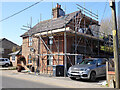
Work on house on Horsham Road, Pease Pottage
Image: © Robin Webster
Taken: 30 Mar 2021
0.09 miles