IMAGES TAKEN NEAR TO
Hawkesmoor Road, CRAWLEY, RH11 8FG
Introduction
This page details the photographs taken nearby to Hawkesmoor Road, RH11 8FG by members of the Geograph project.
The Geograph project started in 2005 with the aim of publishing, organising and preserving representative images for every square kilometre of Great Britain, Ireland and the Isle of Man.

There are currently over 7.5m images from over14,400 individuals and you can help contribute to the project by visiting https://www.geograph.org.uk
Image Map
Images are licensed for reuse under creativecommons.org/licenses/by-sa/2.0
Notes
- Clicking on the map will re-center to the selected point.
- The higher the marker number, the further away the image location is from the centre of the postcode.
Image Listing (88 Images Found)
Images are licensed for reuse under creativecommons.org/licenses/by-sa/2.0
Image
Details
Distance
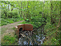
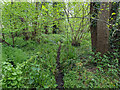
2
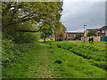
Douster Brook, Bewbush, Crawley
A rather puny channel, but it seems to act together with a more natural parallel watercourse through the trees to the right.
Image: © Robin Webster
Taken: 2 May 2022
0.03 miles
4
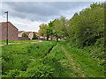
Drain outlet into brook east of mapped Douster Brook
The brook runs in parallel with the named brook, and looks more natural. This whole wooded area is low-lying, the drain may just be a culvert for this under the path. That path needs investigating one day!
Image: © Robin Webster
Taken: 2 May 2022
0.05 miles
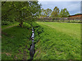
5
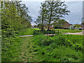
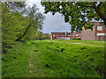
Footbridge over Douster Brook, Bewbush, Crawley
Padstow Walk crosses, a route of some length threading through housing from Gasson Wood Road to Ellman Road.
Image: © Robin Webster
Taken: 2 May 2022
0.07 miles
6
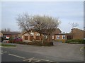
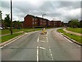
Waterfield Primary School
Opened in 1985 as Waterfield First School, became primary in 2004.
Image: © Michael of Crawley
Taken: 6 Apr 2009
0.07 miles
7
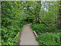
Padstow Walk bridging brook parallel to Douster Brook
Padstow Walk is a route of some length threading through housing from Gasson Wood Road to Ellman Road.
Image: © Robin Webster
Taken: 2 May 2022
0.08 miles
8
Brook east of mapped Douster Brook
The brook runs in parallel with the named brook, and looks more natural. This whole wooded area is low-lying, this may just be a drain for it now. It is only damp in this view.
Image: © Robin Webster
Taken: 2 May 2022
0.08 miles
9
Douster Brook looking upstream
A rather puny channel, but it seems to act together with a more natural parallel watercourse hidden in the trees to the left.
Image: © Robin Webster
Taken: 2 May 2022
0.08 miles