IMAGES TAKEN NEAR TO
Buckmans Road, CRAWLEY, RH11 7DW
Introduction
This page details the photographs taken nearby to Buckmans Road, RH11 7DW by members of the Geograph project.
The Geograph project started in 2005 with the aim of publishing, organising and preserving representative images for every square kilometre of Great Britain, Ireland and the Isle of Man.

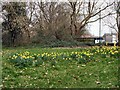
There are currently over 7.5m images from over14,400 individuals and you can help contribute to the project by visiting https://www.geograph.org.uk
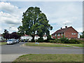
Image Map
Images are licensed for reuse under creativecommons.org/licenses/by-sa/2.0
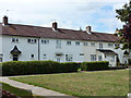
Notes
- Clicking on the map will re-center to the selected point.
- The higher the marker number, the further away the image location is from the centre of the postcode.
Image Listing (203 Images Found)
Images are licensed for reuse under creativecommons.org/licenses/by-sa/2.0
Image
Details
Distance
1
Commemoration of a non-event, West Green Road, Crawley
It is nice to see that non-events are remembered as well as recognized events. Fair shares for all, I say.
Image: © Robin Webster
Taken: 5 Nov 2019
0.03 miles
2
Buckman's Road at Kite Close
Early new town planning when space was not at a premium.
Image: © Robin Webster
Taken: 13 Aug 2013
0.04 miles
3
Houses on Kite Close, West Green, Crawley
Similar terraces face round three sides of a green.
Image: © Robin Webster
Taken: 13 Aug 2013
0.04 miles
4
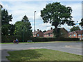
Buckman's Road meets West Green Drive
West Green Drive has a frequent bus service, handy for Crawley Hospital.
Image: © Robin Webster
Taken: 13 Aug 2013
0.05 miles
5
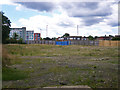
Empty site, West Green, Crawley
The site of a tower block of flats, which stood derelict for some time before being demolished.
Image: © Robin Webster
Taken: 12 Aug 2013
0.06 miles
6
Sunnymead Conservation Area
The Crawley Development Corporation designed Sunnymead Flats in the 1950s. They were originally built for the workers involved in the construction of the New Town. Sunnymead Flats represent an example of early New Town housing and are considered to be of architectural significance. They were designated as a Conservation Area in 1997 http://www.crawley.gov.uk/stellent/idcplg?IdcService=SS_GET_PAGE&ssDocName=INT010073
Image: © Paul Gillett
Taken: 5 Mar 2011
0.08 miles
7
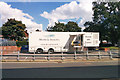
Mobile MRI scanner
Parked outside Crawley Hospital.
Image: © Robin Webster
Taken: 13 Sep 2017
0.09 miles
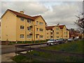
8
Flats, Sunnymead, West Green, Crawley
One of several blocks down this side of the road built on a three-pointed star plan.
Image: © Robin Webster
Taken: 12 Aug 2013
0.09 miles
9
The former Rose and Crown, Ifield Road, West Green, Crawley
Closed by the authorities after repeated trouble, it is now Hallan cash and carry, catering for the Asian market.
Image: © Robin Webster
Taken: 13 Aug 2013
0.09 miles