IMAGES TAKEN NEAR TO
Harmony Close, CRAWLEY, RH11 6BX
Introduction
This page details the photographs taken nearby to Harmony Close, RH11 6BX by members of the Geograph project.
The Geograph project started in 2005 with the aim of publishing, organising and preserving representative images for every square kilometre of Great Britain, Ireland and the Isle of Man.

There are currently over 7.5m images from over14,400 individuals and you can help contribute to the project by visiting https://www.geograph.org.uk
Image Map
Images are licensed for reuse under creativecommons.org/licenses/by-sa/2.0
Notes
- Clicking on the map will re-center to the selected point.
- The higher the marker number, the further away the image location is from the centre of the postcode.
Image Listing (112 Images Found)
Images are licensed for reuse under creativecommons.org/licenses/by-sa/2.0
Image
Details
Distance
1
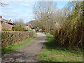
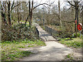
Bridleway 1553, Bewbush, Crawley
Down the north side of Bewbush Water Gardens.
Image: © Robin Webster
Taken: 21 Mar 2021
0.03 miles
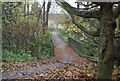
2
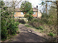
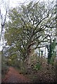
Bridleway 1553, Bewbush, Crawley
The backs of houses on Harmony Close are ahead, the path bends right at the fence.
Image: © Robin Webster
Taken: 21 Mar 2021
0.04 miles
4
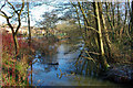
A watery view, Bewbush, Crawley
One of the tails of Ifield Mill Pond.
Image: © Robin Webster
Taken: 2 Jan 2010
0.05 miles
5
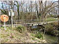
Footbridge over Bewbush Brook, Bewbush, Crawley
The sign says 'Danger deep water', and, remarkably, the lifebelt is in place.
Image: © Robin Webster
Taken: 21 Mar 2021
0.05 miles
6
Footbridge over Bewbush Brook, Bewbush, Crawley
The sign says 'Danger deep water', and, remarkably, the lifebelt is in place.
Image: © Robin Webster
Taken: 21 Mar 2021
0.05 miles

9
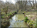
Bewbush Brook, Bewbush, Crawley
Looking upstream, featuring a sheet piled chamber with flooded sheet piled weirs above and below. A similar feature also occurs on the Broadfield Brook - Image Are they silt traps?
Image: © Robin Webster
Taken: 21 Mar 2021
0.06 miles
10
Bridge across Bewbush Brook
A small stream, which rises between Horsham and rawley and flows ENE to Isfield Mill Pond on the edge of Crawley.
Image: © N Chadwick
Taken: 26 Nov 2011
0.06 miles