IMAGES TAKEN NEAR TO
Poles Lane, CRAWLEY, RH11 0PY
Introduction
This page details the photographs taken nearby to Poles Lane, RH11 0PY by members of the Geograph project.
The Geograph project started in 2005 with the aim of publishing, organising and preserving representative images for every square kilometre of Great Britain, Ireland and the Isle of Man.

There are currently over 7.5m images from over14,400 individuals and you can help contribute to the project by visiting https://www.geograph.org.uk
Image Map
Images are licensed for reuse under creativecommons.org/licenses/by-sa/2.0
Notes
- Clicking on the map will re-center to the selected point.
- The higher the marker number, the further away the image location is from the centre of the postcode.
Image Listing (6 Images Found)
Images are licensed for reuse under creativecommons.org/licenses/by-sa/2.0
Image
Details
Distance
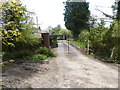
2
Poles Lane
A public bridleway but surfaced for vehicle access.
Image: © Robin Webster
Taken: 30 Jun 2015
0.13 miles
4
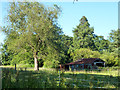
Decrepit shed near footpath 351Sy
This may be associated with the house called The Dell, which is hidden in the trees beyond. Part of the field was grazed by horses.
Image: © Robin Webster
Taken: 30 Jun 2015
0.21 miles
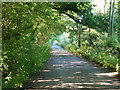
5
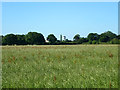
Field near Gatwick Airport
The control tower may be seen across the hedges.
Image: © Robin Webster
Taken: 30 Jun 2015
0.22 miles
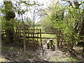
6
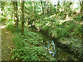
Drain north of Langley Green, Crawley
This fairly large embanked drain appears to have been dug to its present form during the building of the new town of Crawley after the war. It drains surface water from the Langley Green area of Crawley (at least) to the River Mole, emerging above ground north of Langley Walk. Despite its urban origins, a Kingfisher was seen flashing along the watercourse.
Image: © Robin Webster
Taken: 30 Jun 2015
0.23 miles