IMAGES TAKEN NEAR TO
Charman Gardens, CRAWLEY, RH11 0GB
Introduction
This page details the photographs taken nearby to Charman Gardens, RH11 0GB by members of the Geograph project.
The Geograph project started in 2005 with the aim of publishing, organising and preserving representative images for every square kilometre of Great Britain, Ireland and the Isle of Man.

There are currently over 7.5m images from over14,400 individuals and you can help contribute to the project by visiting https://www.geograph.org.uk
Image Map
Images are licensed for reuse under creativecommons.org/licenses/by-sa/2.0
Notes
- Clicking on the map will re-center to the selected point.
- The higher the marker number, the further away the image location is from the centre of the postcode.
Image Listing (126 Images Found)
Images are licensed for reuse under creativecommons.org/licenses/by-sa/2.0
Image
Details
Distance
1
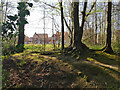
A glimpse of houses, Charman Gardens, Ifield
Image: © Robin Webster
Taken: 26 Mar 2022
0.03 miles
2
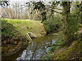
Drain entering Ifield Brook
Fairly new, associated with a housing estate that was built in the last five years.
Image: © Robin Webster
Taken: 2 Apr 2022
0.06 miles
3
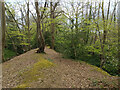
Bank between Ifield Brook and Ifield Mill Stream
The brook is on the right, deeply cut and rather straight compared with the mill stream. The mill stream has a sinuous course, so it seems likely that it was the original course of the brook, and the current brook course is man-made. This bank is probably the spoil from digging the current brook. This must have happened a good while ago, certainly before Ordnance Survey mapping.
Image: © Robin Webster
Taken: 2 Apr 2022
0.07 miles
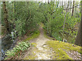
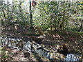
5
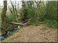
Natural bridge over Ifield Mill Stream
Requiring a confident balance.
Image: © Robin Webster
Taken: 2 Apr 2022
0.08 miles
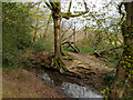
8
Bank between Ifield Brook and Ifield Mill Stream
The brook is on the right, deeply cut and rather straight compared with the mill stream. The mill stream has a sinuous course, so it seems likely that it was the original course of the brook, and the current brook course is man-made. This bank is probably the spoil from digging the current brook. This must have happened a good while ago, certainly before Ordnance Survey mapping.
Image: © Robin Webster
Taken: 2 Apr 2022
0.08 miles
9
Bank between Ifield Brook and Ifield Mill Stream
The brook is on the right, deeply cut and rather straight compared with the mill stream. The mill stream has a sinuous course, so it seems likely that it was the original course of the brook, and the current brook course is man-made. This bank is probably the spoil from digging the current brook. This must have happened a good while ago, certainly before Ordnance Survey mapping.
Image: © Robin Webster
Taken: 2 Apr 2022
0.08 miles
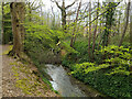
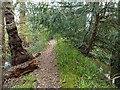
10
Ifield Mill Stream and Ifield Brook
They run very close together here, and here there is an overflow connection. It seems very makeshift, with a bit of sheet piling that seems easily eroded away behind.
Image: © Robin Webster
Taken: 26 Mar 2022
0.08 miles