IMAGES TAKEN NEAR TO
Mill House Court, CRAWLEY, RH11 0BZ
Introduction
This page details the photographs taken nearby to Mill House Court, RH11 0BZ by members of the Geograph project.
The Geograph project started in 2005 with the aim of publishing, organising and preserving representative images for every square kilometre of Great Britain, Ireland and the Isle of Man.

There are currently over 7.5m images from over14,400 individuals and you can help contribute to the project by visiting https://www.geograph.org.uk
Image Map
Images are licensed for reuse under creativecommons.org/licenses/by-sa/2.0
Notes
- Clicking on the map will re-center to the selected point.
- The higher the marker number, the further away the image location is from the centre of the postcode.
Image Listing (125 Images Found)
Images are licensed for reuse under creativecommons.org/licenses/by-sa/2.0
Image
Details
Distance
1
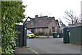
Mill House Court, Ifield, Crawley
The grade II listed Mill House is seen, but the older parts are on the other side. There are also new houses in the grounds.
Image: © Robin Webster
Taken: 21 Mar 2021
0.00 miles
2
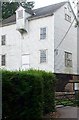
Ifield Mill House
Preserved working Water Mill
Image: © Michael of Crawley
Taken: Unknown
0.01 miles
3
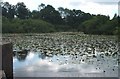
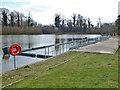
Ifield Mill Pond
Pond connected to Ifield Water Mill
Image: © Michael of Crawley
Taken: Unknown
0.01 miles
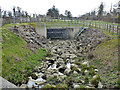
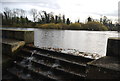
5
Intake for weir, Ifield Mill Pond, Crawley
This is largely under the dam, and appears to be for extreme flood events, certainly the exposed spillway was just about dry. There is a separate weir for normal flows.
Image: © Robin Webster
Taken: 21 Mar 2021
0.04 miles
6
Spillway, Ifield Mill Pond
A spillway into Hyde Hill Brook, which thereafter becomes Ifield Brook. Apparently it works only for higher water levels.
Image: © Robin Webster
Taken: 21 Mar 2021
0.04 miles
7
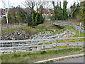
Spillway, Ifield Mill Pond
A spillway into Hyde Hill Brook, which thereafter becomes Ifield Brook. Apparently it works only for extreme events with higher water levels.
Image: © Robin Webster
Taken: 21 Mar 2021
0.04 miles
8
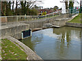
Weir, outlet of Ifield Mill Pond, Crawley
The overflow for normal flows, there is separate provision for extreme events.
Image: © Robin Webster
Taken: 21 Mar 2021
0.04 miles
9
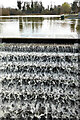
Weir, Ifield Mill Pond, Crawley
A stepped weir showing an extraordinary flow pattern. Are the steps perforated or toothed?
Image: © Robin Webster
Taken: 21 Mar 2021
0.05 miles
10
Outflow from Ifield Mill Pond
The source of the River Mole.
Image: © N Chadwick
Taken: 26 Nov 2011
0.05 miles