IMAGES TAKEN NEAR TO
Olivier Road, CRAWLEY, RH10 7ZG
Introduction
This page details the photographs taken nearby to Olivier Road, RH10 7ZG by members of the Geograph project.
The Geograph project started in 2005 with the aim of publishing, organising and preserving representative images for every square kilometre of Great Britain, Ireland and the Isle of Man.

There are currently over 7.5m images from over14,400 individuals and you can help contribute to the project by visiting https://www.geograph.org.uk
Image Map (Loading...)


Getting Data...Please wait
Leaflet Map data © OpenStreetMap
Images are licensed for reuse under creativecommons.org/licenses/by-sa/2.0
Notes
- Clicking on the map will re-center to the selected point.
- The higher the marker number, the further away the image location is from the centre of the postcode.
Image Listing (283 Images Found)
Images are licensed for reuse under creativecommons.org/licenses/by-sa/2.0
Image
Details
Distance
1
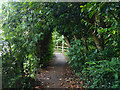
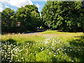
Path along brook, Maidenbower
Towards Balcombe Road, with the brook, which may still be called the Gatwick Stream, down on the right.
Image: © Robin Webster
Taken: 5 Jul 2020
0.03 miles
2
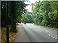
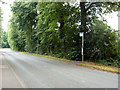
Balcombe Road, B2036
The road bends away from the original route at the junction ahead. This alignment was built in the early 19th century to avoid the short but steep Street Hill on the old route.
Image: © Robin Webster
Taken: 8 Aug 2013
0.04 miles
3
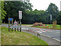
What actually is the speed limit?
Do you compromise at 25 mph? Or 23.3 mph for the mathematically minded?
Image: © Robin Webster
Taken: 8 Aug 2013
0.05 miles
4
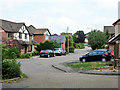
Redgrave Drive, Maidenbower, Crawley
Viewed from the footpath along the bank of the Gatwick Stream.
Image: © Robin Webster
Taken: 8 Aug 2013
0.05 miles
5
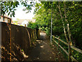
Path along brook, Maidenbower
Towards Balcombe Road, with the brook, which may still be called the Gatwick Stream, down on the right.
Image: © Robin Webster
Taken: 5 Jul 2020
0.05 miles
6
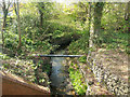
Gatwick Stream?
Looking downstream, this is one of the source streams for what is certainly the Gatwick Stream further down. A path follows it from Balcombe Road.
Image: © Robin Webster
Taken: 5 Jul 2020
0.06 miles
7
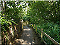
Path along brook, Maidenbower
Towards Balcombe Road, with the brook, which may still be called the Gatwick Stream, down on the right.
Image: © Robin Webster
Taken: 5 Jul 2020
0.06 miles
8
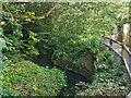
Stream below bridge on Balcombe Road
I can't find a name for this, but it is one of the longer headwaters of the Gatwick Stream.
Image: © Robin Webster
Taken: 22 Apr 2019
0.06 miles
10
Allyington Way bus stop, Balcombe Road, Crawley
Served by the route 100 bus, which at its southern end follows a large single direction loop around the Maidenbower district.
Image: © Robin Webster
Taken: 8 Aug 2013
0.08 miles