IMAGES TAKEN NEAR TO
Mayflower Close, CRAWLEY, RH10 7WH
Introduction
This page details the photographs taken nearby to Mayflower Close, RH10 7WH by members of the Geograph project.
The Geograph project started in 2005 with the aim of publishing, organising and preserving representative images for every square kilometre of Great Britain, Ireland and the Isle of Man.

There are currently over 7.5m images from over14,400 individuals and you can help contribute to the project by visiting https://www.geograph.org.uk
Image Map
Images are licensed for reuse under creativecommons.org/licenses/by-sa/2.0
Notes
- Clicking on the map will re-center to the selected point.
- The higher the marker number, the further away the image location is from the centre of the postcode.
Image Listing (127 Images Found)
Images are licensed for reuse under creativecommons.org/licenses/by-sa/2.0
Image
Details
Distance
1
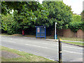
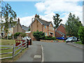
Laud Drive bus stop, Maidenbower, Crawley
Served by Metrobus route 100, which takes a large loop around the Maidenbower neighbourhood, so passes here only left to right. There is a bus stop across the road, but that is for school services only.
Image: © Robin Webster
Taken: 10 Aug 2013
0.03 miles
2
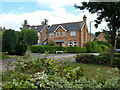
House on the corner, Maidenbower, Crawley
The corner of Collingwood Road and Redgrave Drive.
Image: © Robin Webster
Taken: 10 Aug 2013
0.04 miles
3
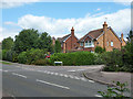
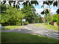
Maidenbower Drive - Redgrave Drive junction, Maidenbower, Crawley
Maidenbower Drive is one of the main routes through the Maidenbower neighbourhood, the rest is a bit of a maze.
Image: © Robin Webster
Taken: 10 Aug 2013
0.04 miles
4
St Vincent Close, Maidenbower, Crawley
Image: © Robin Webster
Taken: 26 Apr 2020
0.04 miles
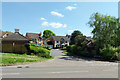
5
Collingwood Road, Maidenbower, Crawley
Albion Close is up on the right.
Image: © Robin Webster
Taken: 10 Aug 2013
0.05 miles
6
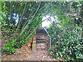
Footpath from old railway to Maidenbower Drive
The final steps up out of Frogshole Gill to Maidenbower Drive.
Image: © Robin Webster
Taken: 5 Jul 2020
0.07 miles
7
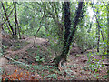
Secondary source in Frogshole Gill
Mapped as 'issues' here. The main stream 'issues' just west of Balcombe Road but has been built over by Georgian Close for a distance. Each 'sinks' on reaching Laud Drive, and are built over beyond, presumably reaching the Gatwick Stream underground. Both were dry at this time in July.
Image: © Robin Webster
Taken: 5 Jul 2020
0.07 miles
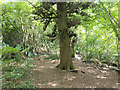
9
Maidenbower Drive at Georgian Close, Crawley
Viewed from the end of the footpath linking down to the Worth Way trail.
Image: © Robin Webster
Taken: 9 Aug 2013
0.08 miles
10
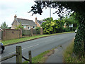
Balcombe Road, B2036
Houses in the Maidenbower area of Crawley are across the road.
Image: © Robin Webster
Taken: 8 Aug 2013
0.08 miles