IMAGES TAKEN NEAR TO
Stanier Close, CRAWLEY, RH10 7UX
Introduction
This page details the photographs taken nearby to Stanier Close, RH10 7UX by members of the Geograph project.
The Geograph project started in 2005 with the aim of publishing, organising and preserving representative images for every square kilometre of Great Britain, Ireland and the Isle of Man.

There are currently over 7.5m images from over14,400 individuals and you can help contribute to the project by visiting https://www.geograph.org.uk
Image Map
Images are licensed for reuse under creativecommons.org/licenses/by-sa/2.0
Notes
- Clicking on the map will re-center to the selected point.
- The higher the marker number, the further away the image location is from the centre of the postcode.
Image Listing (91 Images Found)
Images are licensed for reuse under creativecommons.org/licenses/by-sa/2.0
Image
Details
Distance
1
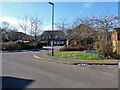
Stanier Close, Maidenbower, Crawley
An area of Maidenbower next to the railway with road names on a railway theme. All that I recognize are either mainly LBSCR locomotive engineers or locomotive names on the Bluebell Railway, except Stanier, who was strictly GWR/LMS with no locomotive on the Bluebell as far as I know.
Image: © Robin Webster
Taken: 12 Feb 2021
0.02 miles
2
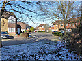
Craven Road, Maidenbower, Crawley
An area of Maidenbower next to the railway with road names on a railway theme. All that I recognize are either mainly LBSCR locomotive engineers or locomotive names on the Bluebell Railway, except Stanier, who was strictly GWR/LMS with no locomotive on the Bluebell as far as I know.
Image: © Robin Webster
Taken: 12 Feb 2021
0.05 miles
3
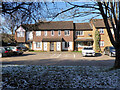
Footpath crossing of Billinton Drive
The path continues to the left of the bush, to eventually pass under the railway.
Image: © Robin Webster
Taken: 8 Aug 2013
0.07 miles
4
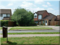
Houses, Craven Road, Maidenbower, Crawley
An area of Maidenbower next to the railway with road names on a railway theme. All that I recognize are either mainly LBSCR locomotive engineers or locomotive names on the Bluebell Railway.
Image: © Robin Webster
Taken: 12 Feb 2021
0.07 miles
5
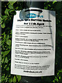
Metrobus coronavirus changes
Note that these are 'further changes' in most cases. The website gives the full picture.
Image: © Robin Webster
Taken: 26 Apr 2020
0.08 miles
6
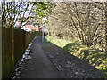
Path along Gatwick Stream, Maidenbower, Crawley
The stream is to the right, beyond the low flood bank.
Image: © Robin Webster
Taken: 12 Feb 2021
0.08 miles
7
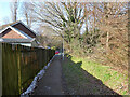
Path along Gatwick Stream, Maidenbower, Crawley
The stream is to the right, beyond the low flood bank.
Image: © Robin Webster
Taken: 12 Feb 2021
0.08 miles
8
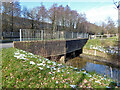
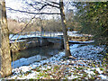
Billinton Drive bridges the Gatwick Stream
Flow is right to left. An odd construction, it may be designed to act as a choke on the flow at high water levels, so bringing the Maidenbower Pond balancing pond into operation. Certainly the earth bunds on this side are not continued on the other side of the road.
Image: © Robin Webster
Taken: 12 Feb 2021
0.10 miles
9
Screen on Gatwick Stream
It does not seem to be a weir, it is just downstream of sluices communicating with a balancing pond off to the left.
Image: © Robin Webster
Taken: 12 Feb 2021
0.10 miles
10
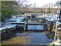
Screen on Gatwick Stream
It does not seem to be a weir, it is just downstream of sluices communicating with a balancing pond off to the right.
Image: © Robin Webster
Taken: 12 Feb 2021
0.10 miles