IMAGES TAKEN NEAR TO
Wandle Close, CRAWLEY, RH10 7UH
Introduction
This page details the photographs taken nearby to Wandle Close, RH10 7UH by members of the Geograph project.
The Geograph project started in 2005 with the aim of publishing, organising and preserving representative images for every square kilometre of Great Britain, Ireland and the Isle of Man.

There are currently over 7.5m images from over14,400 individuals and you can help contribute to the project by visiting https://www.geograph.org.uk
Image Map (Loading...)


Getting Data...Please wait
Leaflet Map data © OpenStreetMap
Images are licensed for reuse under creativecommons.org/licenses/by-sa/2.0
Notes
- Clicking on the map will re-center to the selected point.
- The higher the marker number, the further away the image location is from the centre of the postcode.
Image Listing (107 Images Found)
Images are licensed for reuse under creativecommons.org/licenses/by-sa/2.0
Image
Details
Distance
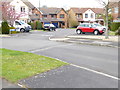
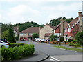
3
Campbell Road, Maidenbower, Crawley
One of the roads in the labyrinthine street layout of Maidenbower, favoured for new developments these days for several reasons, but hard to navigate for the stranger.
Image: © Robin Webster
Taken: 8 Aug 2013
0.03 miles
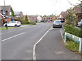
5
Westminster Road, Maidenbower, Crawley
A dead end. One way out is via Campbell Road in the immediate foreground.
Image: © Robin Webster
Taken: 8 Aug 2013
0.04 miles
6
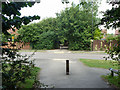
Footpath crossing of Cavell Way
The public footpath is also a designated cycleway.
Image: © Robin Webster
Taken: 8 Aug 2013
0.06 miles
7
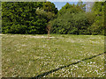
Daisies
On a patch of green by Billinton Drive, Maidenbower, Crawley.
Image: © Robin Webster
Taken: 26 Apr 2020
0.08 miles
8
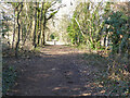
Bridleway 98W, Maidenbower, Crawley
An old route, surviving the development of the Maidenbower neighbourhood around it.
Image: © Robin Webster
Taken: 7 Mar 2021
0.08 miles
9
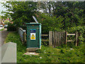
Environment Agency Maidenbower Level Monitoring Site
On the Gatwick Stream. For the equipment in or over the stream see Image
Image: © Robin Webster
Taken: 1 May 2020
0.08 miles
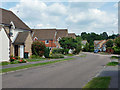
10
Billinton Drive, Maidenbower, Crawley
One of the three roads connecting the Maidenbower district of Crawley with the outside world, all used by the route 100 bus.
Image: © Robin Webster
Taken: 8 Aug 2013
0.08 miles