IMAGES TAKEN NEAR TO
Saxon Road, CRAWLEY, RH10 7SA
Introduction
This page details the photographs taken nearby to Saxon Road, RH10 7SA by members of the Geograph project.
The Geograph project started in 2005 with the aim of publishing, organising and preserving representative images for every square kilometre of Great Britain, Ireland and the Isle of Man.

There are currently over 7.5m images from over14,400 individuals and you can help contribute to the project by visiting https://www.geograph.org.uk
Image Map (Loading...)


Getting Data...Please wait
Leaflet Map data © OpenStreetMap
Images are licensed for reuse under creativecommons.org/licenses/by-sa/2.0
Notes
- Clicking on the map will re-center to the selected point.
- The higher the marker number, the further away the image location is from the centre of the postcode.
Image Listing (296 Images Found)
Images are licensed for reuse under creativecommons.org/licenses/by-sa/2.0
Image
Details
Distance
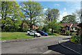
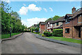
1
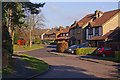
Saxon Road, Worth
All the streets in this estate have names with a Saxon theme, presumably because of the nearby Saxon church of St Nicholas (see Image).
Image: © Ian Capper
Taken: 27 Dec 2008
0.01 miles
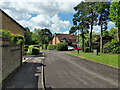
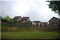
4
Alfred Close, Maidenbower, Crawley
Behind the camera, a path connects to the Worth Way.
Image: © Robin Webster
Taken: 19 May 2021
0.04 miles
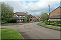
8
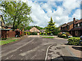
Saxon Road, Worth
All the streets in this estate have names with a Saxon theme, presumably because of the nearby Saxon church of St Nicholas (see Image).
Image: © Ian Capper
Taken: 27 Dec 2008
0.06 miles
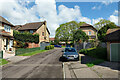
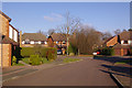
10
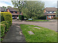
Public footpath 92W, Maidenbower, Crawley
Using here the pavement of part of Saxon Road, crossing the end of Osmund Close and then using its old route towards an end-on junction with path 90W to Turners Hill Road.
Image: © Robin Webster
Taken: 24 May 2021
0.07 miles