IMAGES TAKEN NEAR TO
Stone Court, CRAWLEY, RH10 7RY
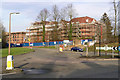
Introduction
This page details the photographs taken nearby to Stone Court, RH10 7RY by members of the Geograph project.
The Geograph project started in 2005 with the aim of publishing, organising and preserving representative images for every square kilometre of Great Britain, Ireland and the Isle of Man.

There are currently over 7.5m images from over14,400 individuals and you can help contribute to the project by visiting https://www.geograph.org.uk
Image Map
Images are licensed for reuse under creativecommons.org/licenses/by-sa/2.0
Notes
- Clicking on the map will re-center to the selected point.
- The higher the marker number, the further away the image location is from the centre of the postcode.
Image Listing (248 Images Found)
Images are licensed for reuse under creativecommons.org/licenses/by-sa/2.0
Image
Details
Distance
1
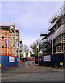
Stone Court building site, 2007
Flats being built on the site of Stone Court. This was a large house with large grounds.
Image: © Robin Webster
Taken: 14 Feb 2007
0.01 miles
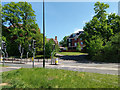
2
Stone Court
A large housing/apartment development on the Balcombe Road, viewed from the Maidenbower Drive/Balcombe Road roundabout. The name derives from the large house previously on the site, also Stone Court, whose grounds make up the bulk of the site.
Image: © Ian Capper
Taken: 27 Dec 2008
0.01 miles
3
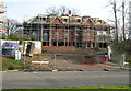
Stone Court - new Block of Flats
This is the earlier (not the earliest) entrance to Stone Court from Balcombe Road when it was a single house. This block of flats is just one of the blocks replacing one dwelling with 120 dwellings.
Image: © Robin Webster
Taken: 14 Feb 2007
0.01 miles
4
Stone Court building site, 2007
Flats being built on the site of Stone Court. This was a large house with large grounds.
Image: © Robin Webster
Taken: 14 Feb 2007
0.01 miles
5
Site Entrance - Stone Court
Urban infilling - Stone Court was a house in large grounds. Now being redeveloped for 120 dwellings.
Image: © Robin Webster
Taken: 14 Feb 2007
0.02 miles
6
Stone Court, Crawley
Flats on the site of a big house with large grounds.
Image: © Robin Webster
Taken: 26 Apr 2020
0.02 miles
7
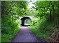
Worth Way, just before passing under B2036, Crawley
The disused railway between Crawley and East Grinstead was converted into a hard surfaced route for non-motorised traffic. Here we see the route heading towards E. Grinstead, just before passing under the Balcombe Road. The tunnel is not an original from the days when steam trains used to ply this route.
Image: © Pete Chapman
Taken: 1 Jul 2005
0.03 miles
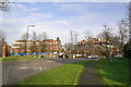
8
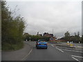
Roundabout on Balcombe Road, Maidenbower
Image: © David Howard
Taken: 26 Apr 2015
0.04 miles
9
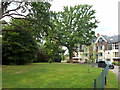
Lawn, Stone Court
Stone Court was formerly a large house in large grounds. It was demolished, and its grounds, plus the ends of some long back gardens on Church Lane, used to build over 100 dwellings of various types.
Image: © Robin Webster
Taken: 8 Aug 2013
0.04 miles
10
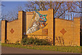
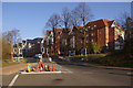
Maidenbower sign
Mosaic sign representing the 1990s development of the Maidenbower district of Crawley, situated on the roundabout where Maidenbower Drive leaves Balcombe Road. It was installed in September 2006, having been created in five pieces, four of them by the four schools in the neighbourhood and the final piece by the community, as a piece of public art.
Image: © Ian Capper
Taken: 27 Dec 2008
0.05 miles