IMAGES TAKEN NEAR TO
Church Road, CRAWLEY, RH10 7RP
Introduction
This page details the photographs taken nearby to Church Road, RH10 7RP by members of the Geograph project.
The Geograph project started in 2005 with the aim of publishing, organising and preserving representative images for every square kilometre of Great Britain, Ireland and the Isle of Man.

There are currently over 7.5m images from over14,400 individuals and you can help contribute to the project by visiting https://www.geograph.org.uk
Image Map
Images are licensed for reuse under creativecommons.org/licenses/by-sa/2.0
Notes
- Clicking on the map will re-center to the selected point.
- The higher the marker number, the further away the image location is from the centre of the postcode.
Image Listing (122 Images Found)
Images are licensed for reuse under creativecommons.org/licenses/by-sa/2.0
Image
Details
Distance
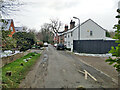
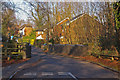
1
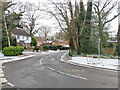
Church Road, Pound Hill, Crawley
The through route sweeps round from Mayfield, before New Town development Church Road continued straight on as a through route to the left, but this is now blocked at Turner's Hill Road.
Image: © Robin Webster
Taken: 10 Feb 2021
0.02 miles
2
Church Road, Pound Hill, Crawley
The through route sweeps round left into Mayfield. Before New Town development Church Road continued straight on as a through route, but this is now blocked just before Turner's Hill Road.
Image: © Robin Webster
Taken: 10 Feb 2021
0.03 miles
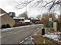
3
Church Road, Worth, at old railway bridge
The narrow bridge is over the course of the former railway from Three Bridges to East Grinstead. This is used by a public footpath here, with no direct access from the road.
Image: © Robin Webster
Taken: 14 Feb 2007
0.05 miles
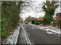
5
Church Road, Pound Hill, Crawley
No longer a through road over this northern part, with some older houses of the old Worth village.
Image: © Robin Webster
Taken: 10 Feb 2021
0.05 miles
6
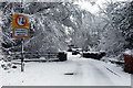
Church Road, Worth, after snow
The narrow bridge is over the course of the former railway from Three Bridges to East Grinstead. This is used by a public footpath here, with no direct access from the road.
Image: © Robin Webster
Taken: 6 Jan 2010
0.06 miles
7
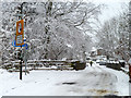
A snowy Church Road, Worth
Here the road crosses the former Three Bridges - East Grinstead railway which is in a deep cutting. It is now a footpath, but with no direct connection to the road at this point.
Image: © Robin Webster
Taken: 5 Feb 2012
0.06 miles
8
Old railway bridge, Church Road, Worth, Crawley
Across the former Three Bridges - East Grinstead line, now mostly a foot and cycle path.
Image: © Robin Webster
Taken: 18 Dec 2009
0.06 miles
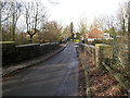
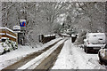
9
Bridge over old railway
This is where Church Road, Worth, crosses the cutting of the former Three Bridges to East Grinstead railway, opened in 1855 and closed in the 1960s. To the west of here, the trackbed forms part of the Worth Way cycle/footpath, which is part of National Cycle Network route 21. However, due to cutting infill further east, including the blocking of the route by the M23 motorway, the cycle route leaves the old railway at this point for around a mile.
Image: © Ian Capper
Taken: 27 Dec 2008
0.06 miles
10
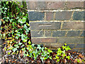
Cut mark on old railway bridge
On the inner face of the east parapet, north end, where Church Road crosses the old railway cutting. Listed elevation is 100.248 m.
Image: © Robin Webster
Taken: 16 May 2021
0.06 miles