IMAGES TAKEN NEAR TO
Maidenbower Place, CRAWLEY, RH10 7QG
Introduction
This page details the photographs taken nearby to Maidenbower Place, RH10 7QG by members of the Geograph project.
The Geograph project started in 2005 with the aim of publishing, organising and preserving representative images for every square kilometre of Great Britain, Ireland and the Isle of Man.

There are currently over 7.5m images from over14,400 individuals and you can help contribute to the project by visiting https://www.geograph.org.uk
Image Map
Images are licensed for reuse under creativecommons.org/licenses/by-sa/2.0
Notes
- Clicking on the map will re-center to the selected point.
- The higher the marker number, the further away the image location is from the centre of the postcode.
Image Listing (105 Images Found)
Images are licensed for reuse under creativecommons.org/licenses/by-sa/2.0
Image
Details
Distance
1
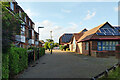
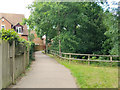
Towards Maidenbower Square, Maidenbower, Crawley
Looking from the path from Maidenbower Drive. On the right is the community centre.
Image: © Robin Webster
Taken: 6 Jul 2021
0.01 miles
2
Glimpse of community centre, Maidenbower, Crawley
Image: © Robin Webster
Taken: 6 Jul 2021
0.02 miles
3
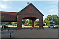
Maidenbower Community Centre
The east side of Maidenbower Square.
Image: © Robin Webster
Taken: 6 Jul 2021
0.03 miles
4
Maidenbower Square, Maidenbower, Crawley
A structure in the middle of the square of no apparent purpose other than a shelter.
Image: © Robin Webster
Taken: 6 Jul 2021
0.04 miles
5
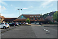
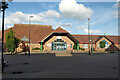
Shops, Maidenbower Square, Crawley
A Co-op with post office, pharmacy and dentist.
Image: © Robin Webster
Taken: 6 Jul 2021
0.04 miles
6
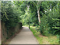
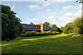
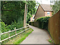
Footpath 102_1W along Stanford Brook
Heading north and downstream.
Image: © Robin Webster
Taken: 11 Jul 2020
0.04 miles
7
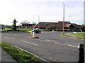
Maidenbower Community Centre
This is the large building beyond the roundabout in one of the newest parts of what used to called the New Town of Crawley. Maidenbower is the name of the area, not invented but the name of a former farm here.
Image: © Robin Webster
Taken: 14 Feb 2007
0.05 miles
8
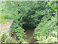
Stanford Brook
Looking north and downstream.
Image: © Robin Webster
Taken: 11 Jul 2020
0.06 miles
9
Footpath 102_1W along Stanford Brook
Heading north and downstream.
Image: © Robin Webster
Taken: 11 Jul 2020
0.06 miles
10
Footpath 102_1W along Stanford Brook
Heading south and upstream.
Image: © Robin Webster
Taken: 11 Jul 2020
0.06 miles