IMAGES TAKEN NEAR TO
Dakin Close, CRAWLEY, RH10 7LL
Introduction
This page details the photographs taken nearby to Dakin Close, RH10 7LL by members of the Geograph project.
The Geograph project started in 2005 with the aim of publishing, organising and preserving representative images for every square kilometre of Great Britain, Ireland and the Isle of Man.

There are currently over 7.5m images from over14,400 individuals and you can help contribute to the project by visiting https://www.geograph.org.uk
Image Map (Loading...)


Getting Data...Please wait
Leaflet Map data © OpenStreetMap
Images are licensed for reuse under creativecommons.org/licenses/by-sa/2.0
Notes
- Clicking on the map will re-center to the selected point.
- The higher the marker number, the further away the image location is from the centre of the postcode.
Image Listing (41 Images Found)
Images are licensed for reuse under creativecommons.org/licenses/by-sa/2.0
Image
Details
Distance
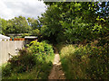
1
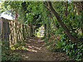
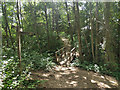
Footpath 81W, Maidenbower
Between the back fences of Maidenbower, following approximately the course of a former track to and past the former Forest Farm. Both of these have been obliterated under the Maidenbower development.
Image: © Robin Webster
Taken: 11 Jul 2020
0.04 miles
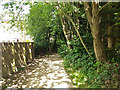
2
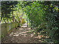
Footpath 81W, Maidenbower
Between the back fences of Maidenbower, following approximately the course of a former track to and past the former Forest Farm. Both of these have been obliterated under the Maidenbower development.
Image: © Robin Webster
Taken: 11 Jul 2020
0.05 miles
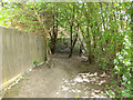
3
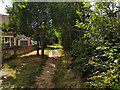
Footpath 81W, Maidenbower
Between the back fences of Maidenbower, following approximately the course of a former track to and past the former Forest Farm. Both of these have been obliterated under the Maidenbower development.
Image: © Robin Webster
Taken: 11 Jul 2020
0.06 miles
6
Footpath 81W, Maidenbower
Between the back fences of Maidenbower, following approximately the course of a former track to and past the former Forest Farm. Both of these have been obliterated under the Maidenbower development.
Image: © Robin Webster
Taken: 11 Jul 2020
0.08 miles
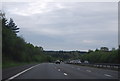
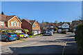
7
Footpath 81W, Maidenbower
At the left corner ahead the number changes to 82W, although just an end to end junction. Possibly this is a consequence of the old paths being disturbed by the M23 construction.
Image: © Robin Webster
Taken: 11 Jul 2020
0.08 miles
10
Footbridge over Halfsmock Stream
Public footpath 82W crosses. This follows the M23 from Balcombe Road, but here starts to bend away between the back fences of Maidenbower, changing number to 81W, following approximately the course of a former track to and past the former Forest Farm. Both of these have been obliterated under the Maidenbower development. To the right starts footpath 102W, following the Halfsmock Stream.
Image: © Robin Webster
Taken: 11 Jul 2020
0.12 miles