IMAGES TAKEN NEAR TO
Shaftesbury Road, CRAWLEY, RH10 7HD
Introduction
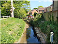
This page details the photographs taken nearby to Shaftesbury Road, RH10 7HD by members of the Geograph project.
The Geograph project started in 2005 with the aim of publishing, organising and preserving representative images for every square kilometre of Great Britain, Ireland and the Isle of Man.

There are currently over 7.5m images from over14,400 individuals and you can help contribute to the project by visiting https://www.geograph.org.uk
Image Map
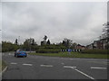
Images are licensed for reuse under creativecommons.org/licenses/by-sa/2.0
Notes
- Clicking on the map will re-center to the selected point.
- The higher the marker number, the further away the image location is from the centre of the postcode.
Image Listing (73 Images Found)
Images are licensed for reuse under creativecommons.org/licenses/by-sa/2.0
Image
Details
Distance
1
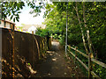
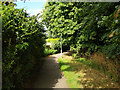
Path along brook, Maidenbower
Towards Balcombe Road, with the brook, which may still be called the Gatwick Stream, down on the right.
Image: © Robin Webster
Taken: 5 Jul 2020
0.05 miles
2
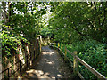
Path along brook, Maidenbower
Towards Balcombe Road, with the brook, which may still be called the Gatwick Stream, down on the right.
Image: © Robin Webster
Taken: 5 Jul 2020
0.06 miles
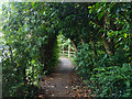
3
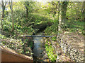
Gatwick Stream?
Looking downstream, this is one of the source streams for what is certainly the Gatwick Stream further down. A path follows it from Balcombe Road.
Image: © Robin Webster
Taken: 5 Jul 2020
0.07 miles
4
Lucerne Drive nearing Balcombe Road roundabout
Image: © Robin Webster
Taken: 14 Feb 2007
0.07 miles
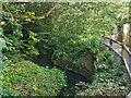
5
Stream below bridge on Balcombe Road
I can't find a name for this, but it is one of the longer headwaters of the Gatwick Stream.
Image: © Robin Webster
Taken: 22 Apr 2019
0.07 miles
6
Path along brook, Maidenbower
Towards Balcombe Road, with the brook, which may still be called the Gatwick Stream, down on the right.
Image: © Robin Webster
Taken: 5 Jul 2020
0.07 miles
7
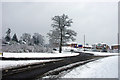
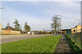
Roundabout and building site, Maidenbower, Crawley
The roundabout on the B2036 give access to the northbound M23 at its junction 10a and also to the Maidenbower neighbourhood of Crawley. Ahead is one of the last parts of Maidenbower to be developed, it lagged some years behind the rest.
Image: © Robin Webster
Taken: 6 Jan 2010
0.07 miles
8
Path along brook, Maidenbower
Towards Balcombe Road, with the brook, which may still be called the Gatwick Stream, down on the right.
Image: © Robin Webster
Taken: 5 Jul 2020
0.08 miles
9
Roundabout on Balcombe Road, Maidenbower
Image: © David Howard
Taken: 26 Apr 2015
0.08 miles
10
Stream upstream of Maidenbower Drive
One of the streams which feeds into the Gatwick Stream and thence the River Mole. It may even be the Gatwick Stream, as the other major stream is called Stanford Brook.
Image: © Robin Webster
Taken: 26 Apr 2020
0.08 miles