IMAGES TAKEN NEAR TO
Furnace Drive, CRAWLEY, RH10 6HZ
Introduction
This page details the photographs taken nearby to Furnace Drive, RH10 6HZ by members of the Geograph project.
The Geograph project started in 2005 with the aim of publishing, organising and preserving representative images for every square kilometre of Great Britain, Ireland and the Isle of Man.

There are currently over 7.5m images from over14,400 individuals and you can help contribute to the project by visiting https://www.geograph.org.uk
Image Map
Images are licensed for reuse under creativecommons.org/licenses/by-sa/2.0
Notes
- Clicking on the map will re-center to the selected point.
- The higher the marker number, the further away the image location is from the centre of the postcode.
Image Listing (29 Images Found)
Images are licensed for reuse under creativecommons.org/licenses/by-sa/2.0
Image
Details
Distance
1
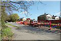
Road up on Hawth Avenue, Crawley
The road was closed to through traffic, although access to the residential roads off it had to be maintained.
Image: © Robin Webster
Taken: 24 Mar 2019
0.05 miles
2
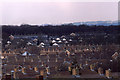
Telephoto view from Tilgate Park in 1987 (6)
The terraced housing in the photo is in Arden Road in the Furnace Green area of Crawley.
Image: © Peter Shimmon
Taken: Unknown
0.07 miles
3
Road up on Hawth Avenue, Crawley
The road was closed to through traffic, although access to the residential roads off it had to be maintained.
Image: © Robin Webster
Taken: 24 Mar 2019
0.07 miles
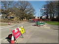
4
Pavilion, Loppets Road Playing Fields
It seems to be hijacked and fenced off for a child care function.
Image: © Robin Webster
Taken: 12 Feb 2021
0.12 miles
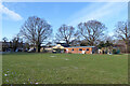
5
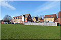
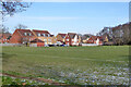
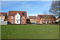
Houses north of Loppets Road Playing Fields, Furnace Green, Crawley
A newish development in a well established area of Crawley. This is because they were built on the site of the demolished Robert May Primary Schools which closed in 1997.
Image: © Robin Webster
Taken: 12 Feb 2021
0.15 miles
6
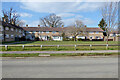
Houses around green, Shackleton Road, Tilgate, Crawley
Image: © Robin Webster
Taken: 7 Mar 2021
0.15 miles
7
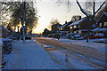
Evening sun on the snow, Arden Road, Crawley
The temperature was dropping as the sun went down, and the compacted snow was getting very slippery.
Image: © Robin Webster
Taken: 18 Dec 2009
0.15 miles
8
Houses north of Loppets Road Playing Fields, Furnace Green, Crawley
A newish development in a well established area of Crawley. This is because they were built on the site of the demolished Robert May Primary Schools which closed in 1997.
Image: © Robin Webster
Taken: 12 Feb 2021
0.16 miles
9
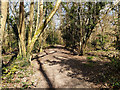
Path in the Hawth, Crawley
This really is a most remarkable wood, it is closely peppered with a great many minepits to extract iron, of the bell pit type. They are partly filled in now, but still show as pits from one up to around three metres deep, and very closely spaced. As I have found before, it is hard to meaningfully photograph the relief in the almost invariable woodland setting. Presumably the woodland came after the mining and because the tract was ruined for anything else without a great deal of effort.
Image: © Robin Webster
Taken: 24 Mar 2019
0.16 miles
10
Houses north of Loppets Road Playing Fields, Furnace Green, Crawley
A newish development in a well established area of Crawley. This is because they were built on the site of the demolished Robert May Primary Schools which closed in 1997.
Image: © Robin Webster
Taken: 12 Feb 2021
0.16 miles