IMAGES TAKEN NEAR TO
Imperial Mews, CRAWLEY, RH10 6FU
Introduction
This page details the photographs taken nearby to Imperial Mews, RH10 6FU by members of the Geograph project.
The Geograph project started in 2005 with the aim of publishing, organising and preserving representative images for every square kilometre of Great Britain, Ireland and the Isle of Man.

There are currently over 7.5m images from over14,400 individuals and you can help contribute to the project by visiting https://www.geograph.org.uk
Image Map
Images are licensed for reuse under creativecommons.org/licenses/by-sa/2.0
Notes
- Clicking on the map will re-center to the selected point.
- The higher the marker number, the further away the image location is from the centre of the postcode.
Image Listing (355 Images Found)
Images are licensed for reuse under creativecommons.org/licenses/by-sa/2.0
Image
Details
Distance
1
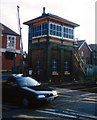
Crawley Signal Box
19th Century Signal Box on Horsham branch line. The box is now out of use following automation, although it is subject to a preservation order, and is cared for by a local society.
Image: © Michael of Crawley
Taken: Unknown
0.00 miles
2
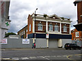
Former Imperial Cinema, Crawley
For sale, having been part of a car main dealer most recently. It was built in 1928.
Image: © Robin Webster
Taken: 12 Aug 2013
0.02 miles
4
Remains of the former Imperial Cinema, 5-7 Brighton Road, Crawley
In April 2015 only the front remained of this former cinema. The larger back part (the auditorium) had been demolished. The cinema opened in 1928 to replace the former Imperial Picture Theatre which had opened in 1911. It was destroyed by fire on the 4th August 1928. The Imperial Cinema had one screen and 506 seats. It closed at some point after the Second World War and then had various uses.
Image: © P L Chadwick
Taken: 18 Apr 2015
0.02 miles
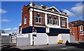
5
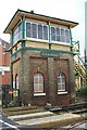
Signal Box at Crawley
For many years this signal box controlled the level crossing gates at a notorious bottle-neck on the London to Brighton road. It is a typical Saxby and Farmer design with hipped roof, sliding windows and top-lights, on a tall brick base. It was erected in 1877 and ceased operational use in 1986. It is Grade 2 listed and looked after by The Crawley Signal Box Preservation Society.
Image: © Elliott Simpson
Taken: 2 Jul 2007
0.02 miles
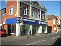
7

Nightingale House at Springfield Road / Brighton Road junction
There is an OS benchmark Image on the near corner of the building at the junction with the brick wall
Image: © Roger Templeman
Taken: 19 Sep 2015
0.03 miles
8
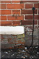
Benchmark on Nightingale House
Ordnance Survey cut mark benchmark described on the Bench Mark Database at http://www.bench-marks.org.uk/bm70495
Image: © Roger Templeman
Taken: 19 Sep 2015
0.03 miles
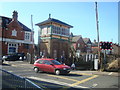
9
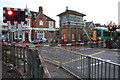
Crawley signal box with train approaching level crossing
Image: © Roger Templeman
Taken: 19 Sep 2015
0.03 miles
10
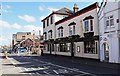
The Railway (1), 2-4 Brighton Road, Crawley, West Sussex
The pub has been well-known for hosting live music since the mid-19th century. It also provides food. In the past it has been known as the Railway Hotel and the Station Hotel. It is now part of the Stonegate Pub Company chain of pubs. It is by the railway line and level crossing in Brighton Road.
Image
Image: © P L Chadwick
Taken: 18 Apr 2015
0.04 miles