IMAGES TAKEN NEAR TO
Turners Hill Road, CRAWLEY, RH10 4EY
Introduction
This page details the photographs taken nearby to Turners Hill Road, RH10 4EY by members of the Geograph project.
The Geograph project started in 2005 with the aim of publishing, organising and preserving representative images for every square kilometre of Great Britain, Ireland and the Isle of Man.

There are currently over 7.5m images from over14,400 individuals and you can help contribute to the project by visiting https://www.geograph.org.uk
Image Map (Loading...)


Getting Data...Please wait
Leaflet Map data © OpenStreetMap
Images are licensed for reuse under creativecommons.org/licenses/by-sa/2.0
Notes
- Clicking on the map will re-center to the selected point.
- The higher the marker number, the further away the image location is from the centre of the postcode.
Image Listing (51 Images Found)
Images are licensed for reuse under creativecommons.org/licenses/by-sa/2.0
Image
Details
Distance
3
Looking west into Grange Road from Turners Hill Road, Crawley Down
Sadly, the sign is ignored by most. Grange Road, named after The Grange in nearby Sand Hill lane.
Image: © CDSnapper
Taken: 8 Nov 2008
0.08 miles
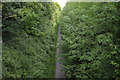
4
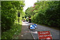
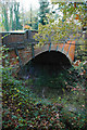
Railway Bridge near Crawley Down
The bridge crosses the disused railway line near to Crawley Down. The old line is a popular route for walkers and cyclists and is known as the Worth Way.
Image: © Chris Thomas-Atkin
Taken: 28 Dec 2017
0.08 miles
6
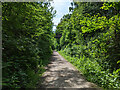
Worth Way towards Crawley
The former Three Bridges - East Grinstead railway line.
Image: © Robin Webster
Taken: 28 May 2023
0.09 miles
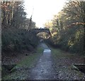
8
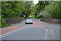
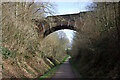
Bridge over the Worth Way, Crawley Down carrying the B2028 Turners Hill Road
This bridge carries the B2028 Turners Hill Road over the disused railway line that is now the Worth Way footpath. The abutments are formed on the cutting rock, part of the Tunbridge Wells Sand.
Image: © CDSnapper
Taken: 8 Nov 2008
0.09 miles
9
Old railway bridge, B2028 Turners Hill Road
Over the course of the former Three Bridges to East Grinstead line, here used by the Worth Way path.
Image: © Robin Webster
Taken: 16 Mar 2009
0.09 miles