IMAGES TAKEN NEAR TO
Eames Way, CRAWLEY, RH10 3XS
Introduction
This page details the photographs taken nearby to Eames Way, RH10 3XS by members of the Geograph project.
The Geograph project started in 2005 with the aim of publishing, organising and preserving representative images for every square kilometre of Great Britain, Ireland and the Isle of Man.

There are currently over 7.5m images from over14,400 individuals and you can help contribute to the project by visiting https://www.geograph.org.uk
Image Map
Images are licensed for reuse under creativecommons.org/licenses/by-sa/2.0
Notes
- Clicking on the map will re-center to the selected point.
- The higher the marker number, the further away the image location is from the centre of the postcode.
Image Listing (114 Images Found)
Images are licensed for reuse under creativecommons.org/licenses/by-sa/2.0
Image
Details
Distance
1
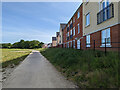
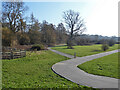
Path, Forge Wood, Crawley
A large area in the flood zone from the Gatwick Stream has been left undeveloped apart from a network of paths.
Image: © Robin Webster
Taken: 29 May 2023
0.04 miles
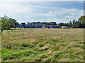
2
Building site, Forge Wood
Work on the western part of this large housing development. The foreground grassland will be left as a flood plain for the Gatwick Stream.
Image: © Robin Webster
Taken: 28 Aug 2017
0.04 miles
3
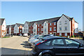
Housing on Cornwell Road, Forge Wood, Crawley
Image: © Robin Webster
Taken: 28 Feb 2021
0.05 miles
4
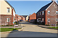
Eames Way, Forge Wood, Crawley
Not more than two or three years old.
Image: © Robin Webster
Taken: 28 Feb 2021
0.05 miles
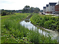
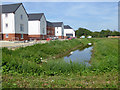
5
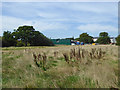
Open space by Gatwick Stream, Forge Wood, Crawley
The stream is on the left.
Image: © Robin Webster
Taken: 28 Feb 2021
0.05 miles
6
Building site, Forge Wood
Work on the western part of this large housing development. The foreground grassland will be left as a flood plain for the Gatwick Stream.
Image: © Robin Webster
Taken: 28 Aug 2017
0.06 miles
7
Improved drain, Forge Wood
An existing ditch has been opened out (or replaced?), presumably to do with flood alleviation on the new Forge Wood development, which is built around the Gatwick Stream, off to the left. The virgin land to the left, between the ditch and the stream, will be left as a flood plain.
Image: © Robin Webster
Taken: 28 Aug 2017
0.06 miles
8
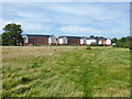
New housing, Forge Wood
Partly occupied housing west of the Gatwick Stream. This area is being built from the north southwards, between the stream and the railway. The large area of foreground grassland will be left as a flood plain.
Image: © Robin Webster
Taken: 28 Aug 2017
0.06 miles
9
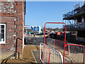
Building site, Forge Wood, Crawley
Looking down a side road off Cornwell Road, just beyond the barrier at the end of the part of road currently open to the public.
Image: © Robin Webster
Taken: 28 Feb 2021
0.06 miles
10
Improved drain, Forge Wood
An existing ditch has been opened out (or replaced?), presumably to do with flood alleviation on the new Forge Wood development, which is built around the Gatwick Stream, off to the right. The virgin land to the right, between the ditch and the stream, will be left as a flood plain.
Image: © Robin Webster
Taken: 28 Aug 2017
0.06 miles