IMAGES TAKEN NEAR TO
Dowlands Lane, CRAWLEY, RH10 3HX
Introduction
This page details the photographs taken nearby to Dowlands Lane, RH10 3HX by members of the Geograph project.
The Geograph project started in 2005 with the aim of publishing, organising and preserving representative images for every square kilometre of Great Britain, Ireland and the Isle of Man.

There are currently over 7.5m images from over14,400 individuals and you can help contribute to the project by visiting https://www.geograph.org.uk
Image Map
Images are licensed for reuse under creativecommons.org/licenses/by-sa/2.0
Notes
- Clicking on the map will re-center to the selected point.
- The higher the marker number, the further away the image location is from the centre of the postcode.
Image Listing (9 Images Found)
Images are licensed for reuse under creativecommons.org/licenses/by-sa/2.0
Image
Details
Distance
1
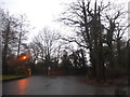
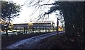
The entrance to Copthorne Business Park
Image: © David Howard
Taken: 15 Jan 2017
0.05 miles
2
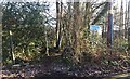
Border Path
The Tandridge Border Path leaves the roadside to head through an area of trees and scrub.
Image: © Chris Thomas-Atkin
Taken: 28 Dec 2017
0.06 miles
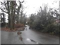
5
Path by Keepers Farm
The footpath that runs beside Keepers Farm.
Image: © Chris Thomas-Atkin
Taken: 28 Dec 2017
0.09 miles
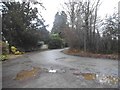
6
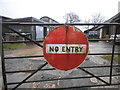
Pre-Worboys no entry sign at Keepers Farm, Copthorne
Presumably no traffic has passed through since a time before 1964.
Image: © David Howard
Taken: 15 Jan 2017
0.12 miles
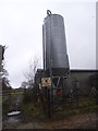
8
Keepers Farm
One of those farms that find a use for a large number of old car tyres.
Image: © Robin Webster
Taken: 30 Jan 2010
0.13 miles
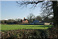
9
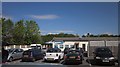
Cophall Farm Parking
One of many parking enterprises in the area for nearby Gatwick Airport. Appropriately, an aircraft is approaching the airport above the building - an Aer Lingus service, I think.
Image: © Derek Harper
Taken: 21 May 2015
0.21 miles