IMAGES TAKEN NEAR TO
West Park Road, CRAWLEY, RH10 3HG
Introduction
This page details the photographs taken nearby to West Park Road, RH10 3HG by members of the Geograph project.
The Geograph project started in 2005 with the aim of publishing, organising and preserving representative images for every square kilometre of Great Britain, Ireland and the Isle of Man.

There are currently over 7.5m images from over14,400 individuals and you can help contribute to the project by visiting https://www.geograph.org.uk
Image Map (Loading...)


Getting Data...Please wait
Leaflet Map data © OpenStreetMap
Images are licensed for reuse under creativecommons.org/licenses/by-sa/2.0
Notes
- Clicking on the map will re-center to the selected point.
- The higher the marker number, the further away the image location is from the centre of the postcode.
Image Listing (19 Images Found)
Images are licensed for reuse under creativecommons.org/licenses/by-sa/2.0
Image
Details
Distance
4
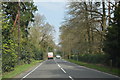
Turf Farming
Perry Farm is flat and ideal for producing turves.
Image: © Nigel Freeman
Taken: 20 Sep 2005
0.15 miles
5
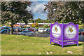
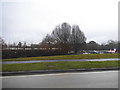
Haskins Garden Centre
Starting in the 1950s as a nursery owned by a Mr Crutchfield, the site was later expanded and developed into Snow Hill Garden Centre. In 2003 it was acquired by a Dorset based company, Haskins, hence its current name.
Image: © Ian Capper
Taken: 19 Aug 2017
0.16 miles
6
Haskins Garden Centre
Starting in the 1950s as a nursery owned by a Mr Crutchfield, the site was later expanded and developed into Snow Hill Garden Centre. In 2003 it was acquired by a Dorset based company, Haskins, hence its current name.
Image: © Ian Capper
Taken: 19 Aug 2017
0.16 miles
7
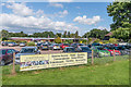
Haskins Garden Centre
Looking across the car park from the entrance. Haskins obtained this site in 2003; the firm has operated in Dorset since 1882. The trees in the background are along the B2028.
Image: © Derek Harper
Taken: 3 Aug 2018
0.17 miles
8
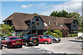
Haskins Garden Centre
Starting in the 1950s as a nursery owned by a Mr Crutchfield, specialising in Dahlias, the site was later expanded and developed into Snow Hill Garden Centre. In 2003 it was acquired by a Dorset based company, Haskins, hence its current name.
This building houses the Centre's café/restaurant.
Image: © Ian Capper
Taken: 19 Aug 2017
0.19 miles
9
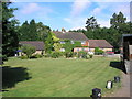
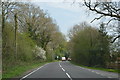
Sheridan Farm, West Park Road, Surrey
Sheridan Farm lies just south of the B2028 near Domewood. The breeding and rearing of racehorses is an important activity here.
Image: © Dr Neil Clifton
Taken: 29 Jul 2006
0.19 miles
10
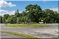
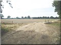
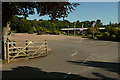
Judge's Corner
Roundabout completed in 2009 at the junction of the B2028 West Park Road and the B2037 Snow Hill/Effingham Road. Originally this was an ordinary crossroads, but around 1960 it was turned into a staggered junction in an attempt to improve traffic flow. However, this proved inadequate, with significant queues building up in both directions on West Park Road. Various options were considered in the 1990s (including even then the provision of a roundabout), but it was not until 2009 that the work was completed.
Although I have not found any evidence supporting this, I assume that the name Judge's Corner refers to John Henderson, who had a house built in adjacent Effingham Park in the 1870s and who among other things was a magistrate.
Image: © Ian Capper
Taken: 19 Aug 2017
0.19 miles