IMAGES TAKEN NEAR TO
The Boulevard, CRAWLEY, RH10 1UR
Introduction
This page details the photographs taken nearby to The Boulevard, RH10 1UR by members of the Geograph project.
The Geograph project started in 2005 with the aim of publishing, organising and preserving representative images for every square kilometre of Great Britain, Ireland and the Isle of Man.

There are currently over 7.5m images from over14,400 individuals and you can help contribute to the project by visiting https://www.geograph.org.uk
Image Map
Images are licensed for reuse under creativecommons.org/licenses/by-sa/2.0
Notes
- Clicking on the map will re-center to the selected point.
- The higher the marker number, the further away the image location is from the centre of the postcode.
Image Listing (373 Images Found)
Images are licensed for reuse under creativecommons.org/licenses/by-sa/2.0
Image
Details
Distance
1
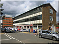
Main post office, Crawley
On a service road off The Boulevard.
Image: © Robin Webster
Taken: 12 Aug 2013
0.02 miles
2
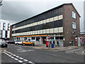
Post Office building, Crawley
This has recently closed its counter, which has transferred to W H Smith in County Mall. A pick-up point for undelivered mail remains open through a small door on the right, as does the back yard together with its non-retail activity.
Image: © Robin Webster
Taken: 2 Apr 2019
0.02 miles
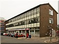
3
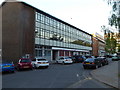
Crawley Main Post Office
A classic 1950s curtain walled building.
Image: © Rod Allday
Taken: 18 May 2014
0.03 miles
4
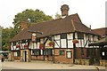
"Old Punch Bowl" public house, Crawley
Grade II* listed building, described at this http://list.english-heritage.org.uk/resultsingle.aspx?uid=1298877. This http://en.wikipedia.org/wiki/Old_Punch_Bowl provides a comprehensive account of this early 15th century building.
Image: © Jim Osley
Taken: 5 Sep 2014
0.03 miles
5
Crawley Post Office, The Boulevard
Built 1959 to the designs of Ministry of Works architect George Albert Henry Pearce. http://britishpostofficearchitects.weebly.com/1959---the-boulevard.html
Image: © Jim Osley
Taken: 5 Sep 2014
0.03 miles
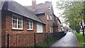
6
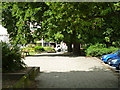
Pavement, north side of The Boulevard, Crawley
Ahead is the High Street.
Image: © Robin Webster
Taken: 12 Aug 2013
0.03 miles
7
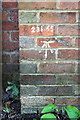
Benchmark on #103 High Street, 'Tree House'
Ordnance Survey cut mark benchmark described on the Bench Mark Database at http://www.bench-marks.org.uk/bm70386 . The height of the mark above mean sea level (Newlyn Datum) of 231.65 feet is painted above the mark.
Image: © Roger Templeman
Taken: 19 Sep 2015
0.03 miles
8
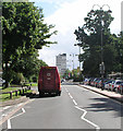
The Boulevard
With the tower of the Central Sussex College providing a dramatic focal point.
Image: © Andy Potter
Taken: 25 Aug 2005
0.04 miles
10
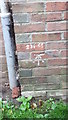
Ordnance Survey Bench Mark
Mark found on wall of 103 High Street, Crawley. These marks were used by ordnance survey for mapping purposes.
Image: © V1ncenze
Taken: 21 Oct 2019
0.04 miles