IMAGES TAKEN NEAR TO
High Street, CRAWLEY, RH10 1DD
Introduction
This page details the photographs taken nearby to High Street, RH10 1DD by members of the Geograph project.
The Geograph project started in 2005 with the aim of publishing, organising and preserving representative images for every square kilometre of Great Britain, Ireland and the Isle of Man.

There are currently over 7.5m images from over14,400 individuals and you can help contribute to the project by visiting https://www.geograph.org.uk
Image Map
Images are licensed for reuse under creativecommons.org/licenses/by-sa/2.0
Notes
- Clicking on the map will re-center to the selected point.
- The higher the marker number, the further away the image location is from the centre of the postcode.
Image Listing (358 Images Found)
Images are licensed for reuse under creativecommons.org/licenses/by-sa/2.0
Image
Details
Distance
1
High Street looking southwards past Travelodge Hotel
For another view of the hotel see http://www.geograph.org.uk/photo/4083135.
Image: © Shazz
Taken: 16 Mar 2016
0.02 miles
3
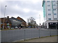
Building site, High Street, Crawley
A Travel Lodge hotel under construction. Beyond will be a Morrisons supermarket. Before this redevelopment, the site as a whole had a cinema, a bowling alley and I think a dance hall, all of which became different things before ultimate demolition.
Image: © Robin Webster
Taken: 12 Aug 2013
0.03 miles
4
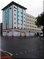
Travelodge, Pegler Way, Crawley, West Sussex
This is a fairly new addition to the chain of Travelodge budget hotels. It is located on the corner of High Street and Pegler Way and is adjacent to the new Morrisons supermarket.
Image: © P L Chadwick
Taken: 19 Jul 2014
0.03 miles
6
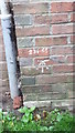
Ordnance Survey Bench Mark
Mark found on wall of 103 High Street, Crawley. These marks were used by ordnance survey for mapping purposes.
Image: © V1ncenze
Taken: 21 Oct 2019
0.03 miles
7
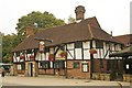
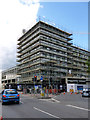
"Old Punch Bowl" public house, Crawley
Grade II* listed building, described at this http://list.english-heritage.org.uk/resultsingle.aspx?uid=1298877. This http://en.wikipedia.org/wiki/Old_Punch_Bowl provides a comprehensive account of this early 15th century building.
Image: © Jim Osley
Taken: 5 Sep 2014
0.04 miles
8
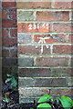
Benchmark on #103 High Street, 'Tree House'
Ordnance Survey cut mark benchmark described on the Bench Mark Database at http://www.bench-marks.org.uk/bm70386 . The height of the mark above mean sea level (Newlyn Datum) of 231.65 feet is painted above the mark.
Image: © Roger Templeman
Taken: 19 Sep 2015
0.04 miles
9
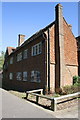
'Tree House', #103 High Street
There is an OS benchmark Image on the front of the building near its far end
Image: © Roger Templeman
Taken: 19 Sep 2015
0.04 miles
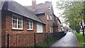
10
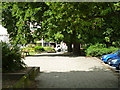
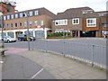
Pavement, north side of The Boulevard, Crawley
Ahead is the High Street.
Image: © Robin Webster
Taken: 12 Aug 2013
0.05 miles