IMAGES TAKEN NEAR TO
RG8 9SN
Introduction
This page details the photographs taken nearby to RG8 9SN by members of the Geograph project.
The Geograph project started in 2005 with the aim of publishing, organising and preserving representative images for every square kilometre of Great Britain, Ireland and the Isle of Man.

There are currently over 7.5m images from over14,400 individuals and you can help contribute to the project by visiting https://www.geograph.org.uk
Image Map
Images are licensed for reuse under creativecommons.org/licenses/by-sa/2.0
Notes
- Clicking on the map will re-center to the selected point.
- The higher the marker number, the further away the image location is from the centre of the postcode.
Image Listing (7 Images Found)
Images are licensed for reuse under creativecommons.org/licenses/by-sa/2.0
Image
Details
Distance
1
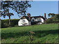
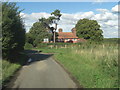
Southridge House from the lane below
We stopped to let some pheasants cross the lane and this striking property was fronting onto the lane higher up the slope. On the gate it states 'house' although the map says 'farm'. Late 17th C with 19th C additions, Grade II listed. English Heritage Building ID: 398268. See: http://www.britishlistedbuildings.co.uk/en-398268-southridge-house-streatley
Image: © Stuart Logan
Taken: 4 Sep 2011
0.06 miles
2
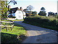
Lane by Southbridge farm
Lane to Stichens Green by Southbridge farm
Image: © Shaun Ferguson
Taken: 17 Oct 2008
0.07 miles
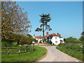
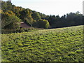
5
Manor Farm Cottages
Just in front of the cottages is the third lane-junction which completes this rural triangle.See:Image]
Image: © Stuart Logan
Taken: 4 Sep 2011
0.18 miles
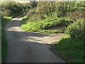
6
Growcroft Copse
Old overgrown farm building on edge of Growcroft Copse
Image: © Shaun Ferguson
Taken: 17 Oct 2008
0.19 miles
7
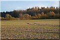
Farmland, Streatley
A crop of linseed with Black Wood in the background.
Image: © Andrew Smith
Taken: 13 Mar 2021
0.24 miles