IMAGES TAKEN NEAR TO
Clay Hill, READING, RG7 5PG
Introduction
This page details the photographs taken nearby to Clay Hill, RG7 5PG by members of the Geograph project.
The Geograph project started in 2005 with the aim of publishing, organising and preserving representative images for every square kilometre of Great Britain, Ireland and the Isle of Man.

There are currently over 7.5m images from over14,400 individuals and you can help contribute to the project by visiting https://www.geograph.org.uk
Image Map
Images are licensed for reuse under creativecommons.org/licenses/by-sa/2.0
Notes
- Clicking on the map will re-center to the selected point.
- The higher the marker number, the further away the image location is from the centre of the postcode.
Image Listing (14 Images Found)
Images are licensed for reuse under creativecommons.org/licenses/by-sa/2.0
Image
Details
Distance
1
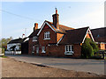
Beenham Village
The pub (The Six Bells) is amongst the first buildings as you enter the village from the north and is situated in the very northern section, in the middle of the grid square. The picture was taken at about 8.20 am.
Image: © Pam Brophy
Taken: 21 Apr 2005
0.12 miles
2
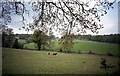
Beenham countryside
On the way to Oakwood Farm
Image: © norman griffin
Taken: 21 Apr 2003
0.13 miles
4
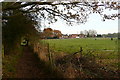
Footpath to Beenham
South of the village there are a few paddocks on the first really flat land above the Kennet valley. This right of way is a footpath though, not a bridleway.
Image: © Graham Horn
Taken: 28 Nov 2010
0.16 miles
6
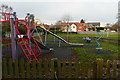
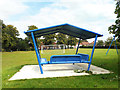
Beenham playing field
After the children have let off steam here, it is the turn of the adults - the pub is just to the right.
Image: © Graham Horn
Taken: 28 Nov 2010
0.16 miles
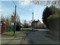
7
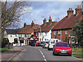
Picklepythe Lane, Beenham
The main road through the village.
Image: © Andrew Smith
Taken: 28 Mar 2010
0.17 miles
8
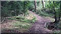
Path heading to Beenham Church
Path from the byway heading to Beenham Church
Image: © Shaun Ferguson
Taken: 4 Sep 2019
0.22 miles
9
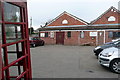
Beenham Hall
This is Beenham Club, the Community Room, built in 1986, one of three halls for hire in Beenham. The telephone box is still in use and is clearly marked on the map. I wonder how much longer many of these will last and how quickly the mapping will catch up?
Image: © Graham Horn
Taken: 28 Nov 2010
0.22 miles
10
Back Lane south of Beenham Primary school
Image: © Stuart Logan
Taken: 16 Feb 2012
0.22 miles