IMAGES TAKEN NEAR TO
The Street, READING, RG7 3PE
Introduction
This page details the photographs taken nearby to The Street, RG7 3PE by members of the Geograph project.
The Geograph project started in 2005 with the aim of publishing, organising and preserving representative images for every square kilometre of Great Britain, Ireland and the Isle of Man.

There are currently over 7.5m images from over14,400 individuals and you can help contribute to the project by visiting https://www.geograph.org.uk
Image Map
Images are licensed for reuse under creativecommons.org/licenses/by-sa/2.0
Notes
- Clicking on the map will re-center to the selected point.
- The higher the marker number, the further away the image location is from the centre of the postcode.
Image Listing (16 Images Found)
Images are licensed for reuse under creativecommons.org/licenses/by-sa/2.0
Image
Details
Distance
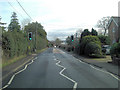
2
Monktons Lane, Stratfield Mortimer
Taken from The Street
Image: © David Howard
Taken: 27 Sep 2015
0.09 miles
3
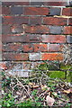
Benchmark on East End House outbuilding, Kiln Lane
Ordnance Survey cut mark benchmark described on the Bench Mark Database at http://www.bench-marks.org.uk/bm54345
Image: © Roger Templeman
Taken: 3 Feb 2014
0.12 miles
4
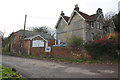
East End House and outbuildings from Kiln Lane
There is an OS benchmark Image on the garage near the telephone pole
Image: © Roger Templeman
Taken: 3 Feb 2014
0.12 miles
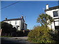
5
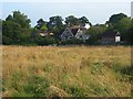
Meadow and houses, Mortimer
Viewed from the footpath below Wheat's Farm. notwithstanding the age of the houses here, this is generally speaking, the older part of Mortimer.
Image: © Andrew Smith
Taken: 30 Aug 2008
0.12 miles
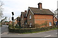
6
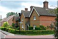
Houses on The Street
These are Victorian, with interesting high chimneys. They mark the western end of Stratfield Mortimer, still just separate from the now larger Mortimer Common. Stratfield Mortimer is seeing a little growth of its own though, as seen by the further houses. The sign is a 30mph reminder sign, powered, as is common these days in rural areas, by a small solar panel.
Image: © Graham Horn
Taken: 19 May 2009
0.12 miles
7
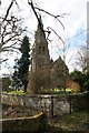
Stratfield Mortimer, Berks
St Mary's Church, Stratfield Mortimer, Berkshire, with the very high spire!
Image: © Brendan and Ruth McCartney
Taken: Unknown
0.13 miles
8
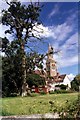
Stratfield Mortimer
The Parish Church of St Mary
Image: © Rosalind Mitchell
Taken: 17 Aug 2002
0.13 miles
9
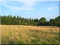
Meadow and woodland, Mortimer
Looking across to Monkton Copse from the footpath below Wheat's Farm.
Image: © Andrew Smith
Taken: 30 Aug 2008
0.13 miles
10
Junction of The Street and Pitfield Lane
There is an Ordnance Survey cut mark benchmark http://www.bench-marks.org.uk/bm54346 on the front of the near corner of the nearest house (#2 Pitt Cottage)
Image: © Roger Templeman
Taken: 3 Feb 2014
0.13 miles