IMAGES TAKEN NEAR TO
Fullbrook Avenue, READING, RG7 1XB
Introduction
This page details the photographs taken nearby to Fullbrook Avenue, RG7 1XB by members of the Geograph project.
The Geograph project started in 2005 with the aim of publishing, organising and preserving representative images for every square kilometre of Great Britain, Ireland and the Isle of Man.

There are currently over 7.5m images from over14,400 individuals and you can help contribute to the project by visiting https://www.geograph.org.uk
Image Map
Images are licensed for reuse under creativecommons.org/licenses/by-sa/2.0
Notes
- Clicking on the map will re-center to the selected point.
- The higher the marker number, the further away the image location is from the centre of the postcode.
Image Listing (9 Images Found)
Images are licensed for reuse under creativecommons.org/licenses/by-sa/2.0
Image
Details
Distance
1
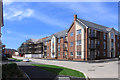
New Housing, Spencers Wood
Shinfiled and Spencers Wood will soon be joined as the remaining fields in between are built over.
Image: © Des Blenkinsopp
Taken: 24 Jul 2019
0.03 miles
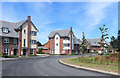
2
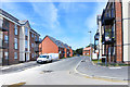
Shipridge Drive, Spencers Wood
A brand new street on former farmland.
Image: © Des Blenkinsopp
Taken: 24 Jul 2019
0.06 miles
3
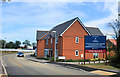
Croft Gardens, Spencers Wood
More new houses. According to the placard they are Finely Crafted, but never mind all that, are they well built?
Image: © Des Blenkinsopp
Taken: 24 Jul 2019
0.09 miles
4
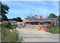
Building Site on Ryeish Lane
This square is currently a large building site as the remaining fields between Shinfield and Spencers Wood are being covered with housing.
Image: © Des Blenkinsopp
Taken: 24 Jul 2019
0.10 miles
5
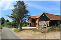
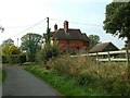
Ryeish Farm
A new house has replaced whatever was here before. The small building nearest is original. The name has been kept although farming has long ceased and all the surrounding fields are being built over.
Image: © Des Blenkinsopp
Taken: 24 Jul 2019
0.14 miles
6
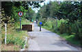
Road Block on Croft Road
For some reason some of the old lanes which used to serve the area have been closed.
Image: © Des Blenkinsopp
Taken: 24 Jul 2019
0.16 miles
7
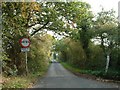
High Copse Farm Road
The road to High Copse Farm - Single track, with no passing places!
Image: © Colin Bates
Taken: 11 Oct 2005
0.16 miles
9
Fullbrook Avenue, Spencers Wood
One of many new roads in this rapidly expanding suburb.
Image: © Des Blenkinsopp
Taken: 24 Jul 2019
0.20 miles