IMAGES TAKEN NEAR TO
Highdown Avenue, READING, RG4 8QT
Introduction
This page details the photographs taken nearby to Highdown Avenue, RG4 8QT by members of the Geograph project.
The Geograph project started in 2005 with the aim of publishing, organising and preserving representative images for every square kilometre of Great Britain, Ireland and the Isle of Man.

There are currently over 7.5m images from over14,400 individuals and you can help contribute to the project by visiting https://www.geograph.org.uk
Image Map
Images are licensed for reuse under creativecommons.org/licenses/by-sa/2.0
Notes
- Clicking on the map will re-center to the selected point.
- The higher the marker number, the further away the image location is from the centre of the postcode.
Image Listing (10 Images Found)
Images are licensed for reuse under creativecommons.org/licenses/by-sa/2.0
Image
Details
Distance
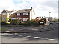
1
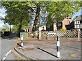
Cherwell Road at the junction of Gravel Hill
Image: © David Howard
Taken: 3 May 2015
0.14 miles
3
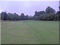
Reading Golf Course 12th green
The most difficult hole, the 12th, culminates in this green in the extreme southwest corner of the course. It plays down into Highdown Bottom and is 472 yards long. Sometimes one plays golf in good weather, but not today.
Image: © Stuart Logan
Taken: 17 Sep 2013
0.19 miles
4
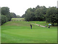
He could hit this ball right out of the county
The golfer taking the putt is standing on the 5th green in Oxfordshire but behind the photographer lies Berkshire. The 5th hole is a beautiful downhill par 4 of 325 yards. It's the easiest on the course. Behind the fence and up the steep sides of Highdown Bottom is the par 3, 6th hole. Just 136 yards but a challenging shot to the green, which is well protected by bunkers S.I. 16.
Image: © Stuart Logan
Taken: 17 Sep 2013
0.19 miles
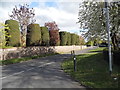
5
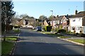
Tredegar Road, Emmer Green, Reading
The road dips down into Hemdean Bottom and leads to more roads with Welsh names.
Image: © Andrew Smith
Taken: 6 Nov 2020
0.20 miles
6
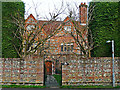
Old Grove House
A 17th century house, the front part of which is constructed in brick and flint - for architectural details, see http://www.imagesofengland.org.uk/Details/Default.aspx?id=39206 .
The side of the building is shown here Image .
Image: © Rose and Trev Clough
Taken: 5 Mar 2014
0.20 miles
7
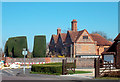
Old Grove House, Emmer Green
An old manor house now surrounded by modern suburb.
Image: © Des Blenkinsopp
Taken: 27 Mar 2012
0.21 miles
8
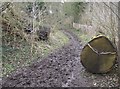
On the bridleway to Tanners Lane
Looking north, gentle climb up past the golf course on the right. This tree would have made quite a thud when it fell. Not surprised the cut section was left pretty much in situ. The bridleways around these parts are very muddy from the recent wet weather.
Image: © Graham Horn
Taken: 24 Feb 2007
0.22 miles
9
Entrance to the golf course
The footpath entrance to the golf course, with a notice which says "You are now entering the Reading golf course. For your own safety please keep to left of the fairway and be aware of golfers coming towards you". To which I would add three comments:
1) Thank you golfers for thinking of walkers.
2) Consider that not all walkers necessarily know what a fairway is.
3) I'd be more concerned about golf balls coming towards me, not golfers.
Image: © Graham Horn
Taken: 24 Feb 2007
0.22 miles
10
Tredegar Road at the junction of Penn Close
Image: © David Howard
Taken: 3 May 2015
0.22 miles