IMAGES TAKEN NEAR TO
Old Bath Road, READING, RG4 6SZ
Introduction
This page details the photographs taken nearby to Old Bath Road, RG4 6SZ by members of the Geograph project.
The Geograph project started in 2005 with the aim of publishing, organising and preserving representative images for every square kilometre of Great Britain, Ireland and the Isle of Man.

There are currently over 7.5m images from over14,400 individuals and you can help contribute to the project by visiting https://www.geograph.org.uk
Image Map
Images are licensed for reuse under creativecommons.org/licenses/by-sa/2.0
Notes
- Clicking on the map will re-center to the selected point.
- The higher the marker number, the further away the image location is from the centre of the postcode.
Image Listing (25 Images Found)
Images are licensed for reuse under creativecommons.org/licenses/by-sa/2.0
Image
Details
Distance
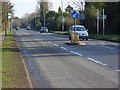
1
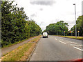
Sonning : Bath Road A4
Looking along Bath Road.
Image: © Lewis Clarke
Taken: 18 Jul 2019
0.08 miles
2
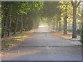
West Drive, Sonning
Looking along the leafy private road from the Old Bath Road.
Image: © Andrew Smith
Taken: 23 Sep 2007
0.08 miles
3
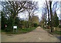
West Drive
A tree lined private road of prosperous housing at its junction with Old Bath Road.
Image: © Des Blenkinsopp
Taken: 7 Mar 2014
0.09 miles
4
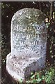
Old Milestone by the A4, south west of Charvil
Carved stone post by the A4, in parish of Sonning (Wokingham District), Bath Road; opposite junction of Holmesmoor Drive and Old Bath Road, in hedge behind path, on North side of road. Bath Road limestone facets, erected by the Twyford & Theale turnpike trust in the 19th century.
Inscription reads:-
: MAIDENHEAD / 10 / COLNBROOK / 19 : : LONDON / 36 / Sonning Parish / 1825 : : READING 3 / NEWBURY 20 / BATH 72 :
Carved benchmark bottom right.
Grade II listed.
List Entry Number: 1117461 https://historicengland.org.uk/listing/the-list/list-entry/1117461
Milestone Society National ID: BE_LB36
Image: © A Rosevear
Taken: 10 Aug 2001
0.10 miles
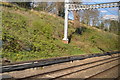
6
Sonning Cutting
Looking down from Warren Road at the cutting's deepest point. In the distance is the Butts Hill Road/Pound Lane bridge in the next grid-square to the east.
Image: © Andrew Smith
Taken: 6 Apr 2008
0.15 miles

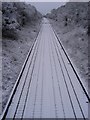
8
Sonning Cutting on the Great Western mainline
Looking east from Warren Road bridge towards Buttshill Bridge. This stretch of railway was the scene of the worst railway accident of its time, when an early morning London to Bristol train hit a landslip on Christmas Eve 1841. Nine of the 38 passengers lost their lives, many of whom were stonemasons who had been working on the new Houses of Parliament and were returning home for Christmas. The inquest started the same day, at nearby Shepherd's House Inn and the findings prompted new safety legislation for railways.
Image: © Simon Mortimer
Taken: 4 Jul 2020
0.16 miles
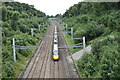
9
The Bath Road (A4), Sonning
This is a relatively new road that bypasses the residential Old Bath Road which runs parallel and just to the south. This is the view from the Sonning Lane crossroads. The speed limit is a fairly draconian 30 mph.
Image: © Andrew Smith
Taken: 24 Feb 2008
0.17 miles
10

Playing fields, Sonning
An oak tree between the various pitches of Berkshire County Sports.
Image: © Andrew Smith
Taken: 16 Nov 2007
0.17 miles