IMAGES TAKEN NEAR TO
Rothwell Walk, READING, RG4 5DB
Introduction
This page details the photographs taken nearby to Rothwell Walk, RG4 5DB by members of the Geograph project.
The Geograph project started in 2005 with the aim of publishing, organising and preserving representative images for every square kilometre of Great Britain, Ireland and the Isle of Man.

There are currently over 7.5m images from over14,400 individuals and you can help contribute to the project by visiting https://www.geograph.org.uk
Image Map
Images are licensed for reuse under creativecommons.org/licenses/by-sa/2.0
Notes
- Clicking on the map will re-center to the selected point.
- The higher the marker number, the further away the image location is from the centre of the postcode.
Image Listing (24 Images Found)
Images are licensed for reuse under creativecommons.org/licenses/by-sa/2.0
Image
Details
Distance
1
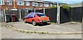
In Need of TLC!
A classic car (MGB GT?) in need of some love and attention to the rear of houses on Rothwell Walk.
Image: © Oscar Taylor
Taken: 14 Jun 2022
0.02 miles
2
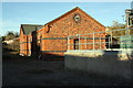
Pump House at north end of drive off Amersham Road
Image: © Roger Templeman
Taken: 14 Nov 2018
0.10 miles
3
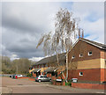
Ian Mikardo Way
Ian Mikardo (9 July 1908 – 6 May 1993) was an influential Labour Party politician.
He was MP for Reading from 1945 to 1959 and has a street in Lower Caversham named after him.
Image: © Des Blenkinsopp
Taken: 4 Apr 2016
0.15 miles
4
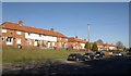
Houses on Lower Henley Road, Caversham
Terraced housing set above the B3345 on the slope of the Brry Brook valley.
Image: © Derek Harper
Taken: 8 Feb 2011
0.16 miles
5
The Red Cow, Star Road
A former Simonds Brewery pub. SeeImage for close up of the old sign.
Image: © Des Blenkinsopp
Taken: 26 Nov 2013
0.18 miles
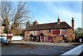
6
Red Cow public house, Caversham
The Red Cow public house on the corner of Star Road and Amersham Road. Grade II listed building.
Image: © Karen Blakeman
Taken: 23 Jan 2011
0.18 miles
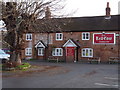
7
Simonds Sign on the Red Cow
This is the Red Cow pub in Star Road.
Simonds Brewery was started in Reading in 1785, later merging with Courage and somehow finally ending up as Fosters. See http://en.wikipedia.org/wiki/Simonds%27_Brewery for history.
I guess brewery mergers leave more of a legacy than in some industries due to the pub badging that goes on.
Tiles and brick reliefs and painted signs etc. are part of the structure and remain long after the original brewery has ceased.
Image: © Des Blenkinsopp
Taken: 26 Nov 2013
0.19 miles
8
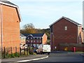
Ruskin, Caversham
A new housing development just off the Henley Road. The decorative use of differently coloured bricks is characteristic of many of Reading's older properties.
Image: © Andrew Smith
Taken: 12 Nov 2007
0.19 miles
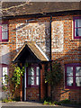
10
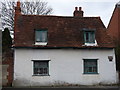
The Moors, 82 Star Road, Caversham - Grade II listed building
Grade II listed building described by English Heritage as "Early C18. Timber framed probably, possibly with brick and flint infill"
Image: © Karen Blakeman
Taken: 2 Feb 2011
0.19 miles