IMAGES TAKEN NEAR TO
Watmore Lane, WOKINGHAM, RG41 5LG
Introduction
This page details the photographs taken nearby to Watmore Lane, RG41 5LG by members of the Geograph project.
The Geograph project started in 2005 with the aim of publishing, organising and preserving representative images for every square kilometre of Great Britain, Ireland and the Isle of Man.

There are currently over 7.5m images from over14,400 individuals and you can help contribute to the project by visiting https://www.geograph.org.uk
Image Map
Images are licensed for reuse under creativecommons.org/licenses/by-sa/2.0
Notes
- Clicking on the map will re-center to the selected point.
- The higher the marker number, the further away the image location is from the centre of the postcode.
Image Listing (5 Images Found)
Images are licensed for reuse under creativecommons.org/licenses/by-sa/2.0
Image
Details
Distance
1
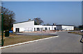
A New School
This brand new primary school is nearing completion on this edge of town site.
Image: © Des Blenkinsopp
Taken: 14 Mar 2014
0.06 miles
2
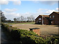
The Winnersh Royal British Legion
The Winnersh Royal British Legion Branch and Social Club.
Image: © don cload
Taken: 19 Feb 2010
0.15 miles
3
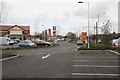
Winnersh
What used to be a fairly "normal" cross-road has now been turned into a major traffic jam by the establishment of a huge supermarket!
Image: © Brendan and Ruth McCartney
Taken: 14 Apr 2005
0.17 miles
4
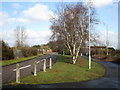
Woodward Close and footpath
The road and the footpath have separate bridges here over the railway. Woodward Close is so called because it is a no through road, despite street maps showing it as a continuous road joining Watmore Lane.
Image: © don cload
Taken: 19 Feb 2010
0.20 miles
5

Windsor and Maidenhead : M4 Motorway
The M4 Motorway between Junction 10 (Winnersh Interchange) and Junction 8/9 (Holyport Interchange).
Image: © Lewis Clarke
Taken: 23 Mar 2018
0.25 miles