
IMAGES TAKEN NEAR TO
Hogwood Lane, WOKINGHAM, RG40 4QW
Introduction
This page details the photographs taken nearby to Hogwood Lane, RG40 4QW by members of the Geograph project.
The Geograph project started in 2005 with the aim of publishing, organising and preserving representative images for every square kilometre of Great Britain, Ireland and the Isle of Man.

There are currently over 7.5m images from over14,400 individuals and you can help contribute to the project by visiting https://www.geograph.org.uk
Image Map
Images are licensed for reuse under creativecommons.org/licenses/by-sa/2.0
Notes
- Clicking on the map will re-center to the selected point.
- The higher the marker number, the further away the image location is from the centre of the postcode.
Image Listing (7 Images Found)
Images are licensed for reuse under creativecommons.org/licenses/by-sa/2.0
Image
Details
Distance
1
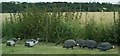
Global warming comes to Finchampstead !
A flock of Helmeted Guinea fowl, normally resident in sub-Saharan Africa, on the Hogwood Lane Industrial estate. Hogwood farm raises these birds, presumably for high class restaurants and they occasionally escape. They are not easily scared, especially in the spring, and will raise themselves on their legs face you and squawk very loudly.
Image: © Len Williams
Taken: 15 Jul 2008
0.07 miles
2
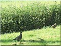
Hogwood Industrial Estate, Partridges
There are no pear trees on the estate, but there are partridges!
This pair nested in the thicket and could be seen most mornings before the workers on the estate started to arrive.
Image: © Len Williams
Taken: 12 May 2008
0.08 miles
3
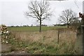
Finchampstead
From Park Lane in the southeast of the square, looking northwest over Hogwood Farm
Image: © Brendan and Ruth McCartney
Taken: Unknown
0.15 miles
4
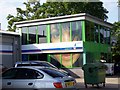
Hogwood Industrial Estate, The Girl !
Putting a picture of your girlfriend in one window, may be OK, but in every window would be considered an overkill, but across all windows !!!!
Image: © Len Williams
Taken: 20 May 2008
0.16 miles
5
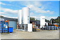
Siren Craft Brewery
One of the businesses on the Hogwood Industrial Estate.
Image: © Des Blenkinsopp
Taken: 1 Sep 2020
0.17 miles
6
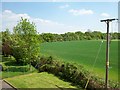
Hogwood Industrial Estate, View 1
This view taken from my office window and shows the terminus of "9 Mile Ride", a road that extends in a straight line from Bracknell to Finchampstead terminating in a T junction behind the line of trees. This road passes Caesar's Camp, a Celtic Hill Fort, believed to mark the Northern boundary of the Atrebatic Tribe, prior to the Roman conquest.
Image: © Len Williams
Taken: 7 May 2008
0.22 miles
7

Park Lane
Heading towards Arborfield Garrison.
Image: © Mr Ignavy
Taken: 10 Apr 2011
0.25 miles